place

Bishop Challoner Catholic Collegiate School

AC with 0 elementsCatholic secondary schools in the Archdiocese of WestminsterSecondary schools in the London Borough of Tower HamletsVoluntary aided schools in London

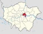
Bishop Challoner Catholic Federation of Schools is a Roman Catholic secondary school and sixth form, located in the Shadwell area of the London Borough of Tower Hamlets, England. In May 2015, the name of the schools formally changed from "the Collegiate" to its current nomenclature of Bishop Challoner Catholic Federation of Schools. The school is a voluntary aided federation of a boys' school, a girls' school and a co-educational sixth form. The school is administered by Tower Hamlets London Borough Council and the Roman Catholic Archdiocese of Westminster. In 2016, around 50% of the intake was Roman Catholic. Whilst the pupil profile at Bishop Challoner is diverse, Bangladeshi children are very significantly under-represented in comparison to Tower Hamlets as a whole and the schools receive few applications from Bangladeshi parents. Nevertheless, in 1992, local parents unsuccessfully challenged the admission policy to Bishop Challoner RC Girls' School in the House of Lords (R v Governors of the Bishop Challoner Roman Catholic Comprehensive Girls' School ex parte Choudhury and Purkayastha). Tower Hamlets Borough’s high levels of child poverty are evident in the high proportion of children entitled to free school meals which in 2011 stood at 57%.

Excerpt from the Wikipedia article Bishop Challoner Catholic Collegiate School (License: CC BY-SA 3.0, Authors).

Bishop Challoner Catholic Collegiate School
Commercial Road, London Stepney

Geographical coordinates (GPS) Address Website Nearby Places
placeShow on map

Wikipedia: Bishop Challoner Catholic Collegiate SchoolContinue reading on Wikipedia

Geographical coordinates (GPS)

Latitude Longitude
N 51.51312 ° E -0.051465 °
placeShow on map

Address

Bishop Challoner Catholic Federation of Schools (Bishop Challoner Girls' School)

Commercial Road 352
E1 0LB London, Stepney
England, United Kingdom
mapOpen on Google Maps

Website
bishopchallonerfederation.towerhamlets.sch.uk

linkVisit website

Share experience

Nearby Places

Shadwell & St. George's East railway station

Shadwell was a railway station in the parish of St. George in the East, London, that was opened by the Commercial Railway (later the London and Blackwall Railway). It was situated 50 yards to the east of the current Shadwell DLR station on the Docklands Light Railway, with the former station entrance on Sutton Street (Shadwell DLR's entrance is on Watney Street). The former station was between Cannon Street Road and Stepney (now called Limehouse), and was 1 mile 5 chains (1.7 km) down-line from Fenchurch Street.Shadwell opened in October 1840, three months after the opening of the rest of the Commercial Railway, which rebranded as the LBR in 1841. It was eventually incorporated into the London, Tilbury and Southend Railway (LTSR) and was rebuilt in 1895 when the railway was widened to four tracks; Shadwell only served the slow lines on the south side. In 1900, the station was renamed Shadwell & St. George's East, possibly to distinguish it from the East London Railway (ELR) station of the same name. Apart from a wartime closure between 1916 and 1919, Shadwell & St. George's East remained open until July 1941, when dwindling passenger numbers forced its then owner, the London and North Eastern Railway, to close both it and Leman Street station. Some remains of the station can still be seen today: the westbound platform has partially survived although it is somewhat dilapidated, and the red brick station entrance on Sutton Street still survives. The Docklands Light Railway Shadwell station has been built partly on the site of the station.

East End of London
East End of London

The East End of London, often referred to within the London area simply as the East End, is the historic core of wider East London, east of the Roman and medieval walls of the City of London and north of the River Thames. It does not have universally accepted boundaries to the north and east, though the River Lea is sometimes seen as the eastern boundary. Parts of it may be regarded as lying within Central London (though that term too has no precise definition). The term "East of Aldgate Pump" is sometimes used as a synonym for the area. The East End began to emerge in the Middle Ages with initially slow urban growth outside the eastern walls, which later accelerated, especially in the 19th century, to absorb pre-existing settlements. The first known written record of the East End as a distinct entity, as opposed to its component parts, comes from John Strype's 1720 Survey of London, which describes London as consisting of four parts: the City of London, Westminster, Southwark, and "That Part beyond the Tower". The relevance of Strype's reference to the Tower was more than geographical. The East End was the urbanised part of an administrative area called the Tower Division, which had owed military service to the Tower of London since time immemorial. Later, as London grew further, the fully urbanised Tower Division became a byword for wider East London, before East London grew further still, east of the River Lea and into Essex. The area was notorious for its deep poverty, overcrowding and associated social problems. This led to the East End's history of intense political activism and association with some of the country's most influential social reformers. Another major theme of East End history has been migration, both inward and outward. The area had a strong pull on the rural poor from other parts of England, and attracted waves of migration from further afield, notably Huguenot refugees, Irish weavers, Ashkenazi Jews and in the 20th century, Sylhetis. The closure of the last of the Port of London's East End docks in 1980 created further challenges and led to attempts at regeneration, with Canary Wharf and the Olympic Park among the most successful examples. While some parts of the East End are undergoing rapid change, the area continues to contain some of the worst poverty in Britain.

London Borough of Tower Hamlets

The London Borough of Tower Hamlets is a London borough covering much of the traditional East End. It was formed in 1965 from the merger of the former metropolitan boroughs of Stepney, Poplar, and Bethnal Green. 'Tower Hamlets' was originally an alternative name for the historic Tower Division; the area of south-east Middlesex, focused on (but not limited to) the area of the modern borough, which owed military service to the Tower of London. The borough lies on the north bank of the River Thames immediately east of the City of London, and includes much of the redeveloped Docklands area. Some of the tallest buildings in London occupy the centre of the Isle of Dogs in the south of the borough. A part of the Queen Elizabeth Olympic Park is in Tower Hamlets. The 2019 mid-year population for the borough is estimated at 324,745. Asian/Asian British Bangladeshis at 32% form the largest ethnic group. The 2011 census showed Tower Hamlets to have the highest proportion of Muslims of any English local authority and that Muslims outnumbered Christians. The borough has more than forty mosques and Islamic centres, including the East London Mosque, one of Britain's largest. Brick Lane's restaurants, neighbouring street market and shops provide the largest range of Bengali cuisine, woodwork, carpets and clothes in Europe. The Lane is also a major centre of hipster subculture.In 2017 a joint study by Trust for London and New Policy Institute found Tower Hamlets to be the 2nd most deprived London borough (after Barking and Dagenham) based on an average calculated across a range of indicators; with high rates of poverty, child poverty, unemployment and pay inequality compared to other London boroughs. However, it has the lowest gap for educational outcomes at secondary level.The local authority is Tower Hamlets London Borough Council.

Arbour Square
Arbour Square

Arbour Square is a late Georgian square in Stepney, in the borough of Tower Hamlets, east London, England. It is located just off the Commercial Road (A13) approximately one mile (1.6 km) east of the City of London. The square is currently laid out as a formal garden with mature trees and planting and is surrounded on two sides by elegant early 19th century townhouses. Arbour Square was laid out as a garden enclosure in 1819. By 1830, contemporary maps show buildings on all sides of the square and many of the surrounding roads. The south and west sides of the square are still made up of the original three and four storey Georgian townhouses which are Grade II listed. The east side was demolished and replaced by the Raine's School building (also Grade II listed) in 1913, while the terrace on the north side was replaced by a block of flats in 1937. The Raine's School building now houses part of Tower Hamlets College. The school building was entirely refurbished in 1994 by Sprunt Architects, featuring a new open learning centre within the listed heart of the building. Running north from the square on the west side is West Arbour Street; and running north on the east side is East Arbour street which is a smaller two storey Georgian terrace. The former Arbour Square police station which once held the Kray Twins and alleged Provisional Irish Republican Army terrorists is located between these two streets; it closed in 1999 and has recently been redeveloped into flats.Arbour Square is mirrored on the opposite side of commercial road by Albert Gardens, an impressive and almost fully intact late-Georgian residential square made up of Grade II listed houses. Originally named Albert Square, it was built in the early 1840s, and renamed Albert Gardens in 1937. In 1899 there was a proposal to build houses on the central garden in the square but the London County Council compulsorily purchased the land and opened Albert Square Garden to the public in 1906. In the north of the garden is a 19th-century drinking fountain topped by a statue, 'Shepherd Boy', which was erected in 1903 by the Metropolitan Public Gardens AssociationTogether with the neighbouring Havering Street which contains smaller but also Grade II listed houses, and several other early 19th century terraces on the Commercial Road, Albert Gardens and Arbour Square became part of the Albert Gardens Conservation area in 1969. Havering Street, Arbour Square, and Albert Gardens are some of the last remaining original late-Georgian houses in the E1 postcode area of London's East End.In the 1970s, council-owned houses on the square were squatted by the Campaign to Clear Hostels and Slums, which installed working class families.