place

Loring Park

1883 establishments in MinnesotaGay villages in the United StatesNeighborhoods in MinneapolisParks in MinneapolisProtected areas established in 1883
Regional parks in Minnesota
MinneapolisLoringParkNeighborhood

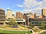
Loring Park is the largest park in the Central Community of Minneapolis, Minnesota. Located on the southwest corner of downtown Minneapolis, it also lends its name to the surrounding neighborhood.

Excerpt from the Wikipedia article Loring Park (License: CC BY-SA 3.0, Authors, Images).

Loring Park
Harmon Place, Minneapolis

Geographical coordinates (GPS) Address Nearby Places
placeShow on map

Wikipedia: Loring ParkContinue reading on Wikipedia

Geographical coordinates (GPS)

Latitude Longitude
N 44.97 ° E -93.283888888889 °
placeShow on map

Address

Garden of the Seasons

Harmon Place
55403 Minneapolis
Minnesota, United States
mapOpen on Google Maps

MinneapolisLoringParkNeighborhood
Share experience

Nearby Places

Loring Greenway
Loring Greenway

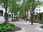
Loring Greenway is a 1,500-foot linear pedestrian greenway in downtown Minneapolis that connects Nicollet Mall with Loring Park. It was designed by landscape architect M. Paul Friedberg, who also designed Peavey Plaza near the Nicollet Mall end of the greenway. Opened in 1979, it was part of the Loring Park Development District that razed older properties, created the adjacent Hyatt hotel and built new surrounding multi-family apartment and townhouse buildings in the Loring Park neighborhood. Now approximately 2,500 housing units flank the greenway spine. Originally retail businesses were planned to line the greenway, but private development focused on residential, and the small commercial spaces never materialized. The greenway is noted on a historic marker in a series along the north side of West Grant Street between LaSalle and Nicollet.Larry Millett called the greenway "the most notable public amenity" in the Loring Park Development District. In the book Intown Living: A Different American Dream, authors Ann Breen and Dick Rigby highlighted the contrast of the lush greenway and its quiet with the "hard-edged" and relatively treeless Nicollet Mall.The Modernist style greenway includes two fountains, one at the Nicollet Mall entrance and one halfway along the greenway. The public space also includes seating areas and a playground and is lighted at night with custom distinctive lights. Part of the greenway includes a land bridge over Lasalle Avenue. The greenway connects Nicollet Mall with Loring Park and ends at the site of the Berger dandelion fountain in the park, which was envisioned as the terminus of the greenway. Two extensions from the greenway connect to Spruce Place and 13th Street. The Nicollet Mall entrance to the greenway hosts George Morrison's "Tableau," a granite pavement mosaic, part of the public art on Nicollet Mall. This work was moved to the location by the greenway after being in two other locations on Nicollet Mall; the greenway entrance was thought to be lesser impact on the art work. Friedberg intended for the greenway to be like a procession and wished for it to be a community of people living along it. In an interview with Charles Birnbaum in 2006, Friedberg described it as "We're in this together. This is how you get to the park. That's the event. This is the procession to the event. There are minor events, and make use of it. That's what we want you to do. You're part of a city."The greenway has high pedestrian counts according to regular counts done by the city. In 2018, the mall end of the greenway had 2,850 estimated daily pedestrians and 410 bicyclists.

Minneapolis Sculpture Garden

The Minneapolis Sculpture Garden is an 11-acre (4.5 ha) park in Minneapolis, Minnesota, in the United States. It is located near the Walker Art Center, which operates it in coordination with the Minneapolis Park and Recreation Board. It reopened June 10, 2017 after a reconstruction that resulted with the Walker and Sculpture Garden being unified as one 19-acre campus. It is one of the largest urban sculpture gardens in the country, with 40 permanent art installations and several other temporary pieces that are moved in and out periodically.The park is located to the west of Loring Park and the Basilica of Saint Mary. The land was first purchased by the park board around the start of the 20th century, when it was known as "The Parade" because it had been used for military drills. It became known as the Armory Gardens after park superintendent Theodore Wirth created a formal design that included a U.S. National Guard armory (Kenwood Armory) for Spanish War volunteers. Working as a civic and cultural center, in 1913 a floral convention transformed the land into floral gardens, which it remained for the next 50 years. In 1934, six years after the Walker Art Gallery opened across the street, the Armory was demolished for its instability, and a new Armory built in downtown Minneapolis, turning the Armory Gardens over to the Minneapolis Park Board. Since 1908 the area of today's Sculpture Garden and land to the west had been used for sport recreation via mildly-improved playing fields and the 1950 construction of the original Parade Stadium. In 1988, the Minneapolis Sculpture Garden opened, designed by Edward Larrabee Barnes and landscape architects Quinnel and Rothschild. Parade Stadium was demolished in 1990, two years later the Garden was expanded, adding 3.5 acres (1.4 ha). Michael Van Valkenburgh and Associates, Inc. designed the northward extension to complement the original space with a more open area that features a walkway and the 300-foot-long (91 m) Alene Grossman Memorial Arbor. The centerpiece of the garden is the Spoonbridge and Cherry (1985–1988) fountain designed by husband and wife Claes Oldenburg and Coosje van Bruggen.A pedestrian bridge, the Irene Hixon Whitney Bridge (1987), designed by Siah Armajani, now crosses Hennepin Avenue, connecting the sculpture garden to Loring Park.