place

Notre-Dame-des-Anges, Quebec

Catholic missions of New FranceFrench Colonial architecture in CanadaIncorporated places in Capitale-NationalePages with non-numeric formatnum argumentsParish municipalities in Quebec
Québec Notre Dame des Anges

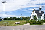
Notre-Dame-des-Anges is a parish municipality in Quebec, Canada, home of the General Hospital of Quebec. Enclaved within the territory of Quebec City, this unusual municipality had a population of 241 and measures only 6 hectares (15 acres) in area, making it the smallest incorporated municipal entity in Canada. With a density of 6,478.5/km2 (16,779/sq mi) according to Statistics Canada, it is the second densest census subdivision in Canada.It lacks any governmental structure and has no mayor but rather an "administrator."

Excerpt from the Wikipedia article Notre-Dame-des-Anges, Quebec (License: CC BY-SA 3.0, Authors, Images).

Notre-Dame-des-Anges, Quebec
Rue de la Maréchaussée, Quebec Saint-Roch (La Cité-Limoilou)

Geographical coordinates (GPS) Address Nearby Places
placeShow on map

Wikipedia: Notre-Dame-des-Anges, QuebecContinue reading on Wikipedia

Geographical coordinates (GPS)

Latitude Longitude
N 46.816666666667 ° E -71.233333333333 °
placeShow on map

Address

Club social Victoria

Rue de la Maréchaussée
G1K 2L3 Quebec, Saint-Roch (La Cité-Limoilou)
Quebec, Canada
mapOpen on Google Maps

Québec Notre Dame des Anges
Share experience

Nearby Places

Cartier-Brébeuf National Historic Site

Cartier-Brébeuf National Historic Site is a National Historic Site of Canada and so designated by the Historic Sites and Monuments board of Canada in 1958 under the recommendation of John Diefenbaker, the Prime Minister of Canada at the time. It is administered by Parks Canada and located at the confluence of Saint-Charles and Lairet rivers, in Quebec City, Quebec, Canada, more precisely in La Cité-Limoilou borough. On the site you can find an interpretation centre and a 6,8 hectares inner-city park characterised by an uneven landscape and divided into two sectors "East" and "West" separated by the Lairet river. Several commemorative monuments and elements are also present. The site commemorates the second voyage of Jacques Cartier; more precisely in 1535-1536 when he and his shipmates wintered near the Iroquoian village of Stadacona (Quebec City). It also recalls the establishment of the first residence of the Jesuit missionaries in Quebec, in 1625-1626. Moreover, by the end of the 17th century up to the opening of the national historic site in 1972, it hosted numerous hand-crafted and industrial activities such as a tannery, a pottery, a brickyard, a shipyard, a sawmill, a junkyard and a snow-dumping lot. Today, the site offers a museum exhibition, animations for elementary and high school groups, thematic events, and a natural habitat in an inner-city park. A cycleway and the linear park of Saint-Charles river also cross the park's ground.