Quebec (census division)
Census divisions of QuebecQuebec stubsTerritories equivalent to a regional county municipality

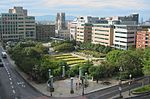
Québec is a territory equivalent to a regional county municipality (TE) and census division (CD) of Quebec. Its geographical code is 23. The TE of Québec consists of: the three municipalities of the urban agglomeration of Quebec City, namelythe city of Quebec, the city of L'Ancienne-Lorette, and the city of Saint-Augustin-de-Desmaures;the parish municipality of Notre-Dame-des-Anges; and the Indian reserve of Wendake.
Excerpt from the Wikipedia article Quebec (census division) (License: CC BY-SA 3.0, Authors, Images).Quebec (census division)
Rue de la Reine, Quebec Saint-Roch (La Cité-Limoilou)
Geographical coordinates (GPS) Address Nearby Places Show on map
 Continue reading on Wikipedia
 Geographical coordinates (GPS)
| Latitude | Longitude |
|---|---|
| N 46.8161 ° | E -71.2242 ° |
Address
Rue de la Reine 523
G1K 6A2 Quebec, Saint-Roch (La Cité-Limoilou, District03)
Quebec, Canada
Open on Google Maps