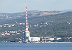
Sveti Kuzam
Populated places in Primorje-Gorski Kotar CountyPrimorje-Gorski Kotar County geography stubs

Sveti Kuzam is a village located between Bakar and Rijeka in Primorje-Gorski Kotar County, Croatia. The village is administered as a part of the City of Rijeka. The village was recorded on the 2011 Croatian census as a settlement named "Bakar" with a population of 240. The 2006 law on administrative divisions mentions no other settlement within the City of Rijeka. On 27 February 2014, Rijeka city council passed a decision to annex the settlement (named "Bakar-dio (Sv. Kuzam")) to the settlement of Rijeka.
Excerpt from the Wikipedia article Sveti Kuzam (License: CC BY-SA 3.0, Authors, Images).Sveti Kuzam
5205, Grad Rijeka Mjesni odbor Sveti Kuzam (Rijeka)
Geographical coordinates (GPS) Address Nearby Places Show on map
Geographical coordinates (GPS)
| Latitude | Longitude |
|---|---|
| N 45.314722222222 ° | E 14.526388888889 ° |
Address
5205
51227 Grad Rijeka, Mjesni odbor Sveti Kuzam (Rijeka)
Croatia
Open on Google Maps


