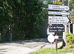
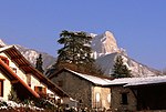
Chamechaude
France geography stubsMountains of IsèreMountains of the AlpsPages with French IPATwo-thousanders of France

Chamechaude (French pronunciation: [ʃamʃod]) is the highest summit in the Chartreuse Massif in the Isère department in eastern France. It is the fourth most prominent mountain in metropolitan France.
Excerpt from the Wikipedia article Chamechaude (License: CC BY-SA 3.0, Authors, Images).Chamechaude
Le canyon, Grenoble
Geographical coordinates (GPS) Address Nearby Places Show on map
Geographical coordinates (GPS)
| Latitude | Longitude |
|---|---|
| N 45.288055555556 ° | E 5.79 ° |
Address
Le canyon
38380 Grenoble
Auvergne-Rhône-Alpes, France
Open on Google Maps


