Col de Porte
IsèreMountain passes of Auvergne-Rhône-Alpes

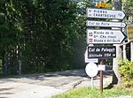
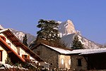
The Col de Porte (elevation 1,326 m (4,350 ft)) is a mountain pass situated in the Chartreuse Mountains in the Isère department of France, between Le Sappey-en-Chartreuse to the south and Saint-Pierre-de-Chartreuse to the north. It sits on the D512 between Grenoble and Chambéry, and prior to 1998 was often crossed in conjunction with the Col du Cucheron and the Col du Granier.To the east is Chamechaude, the highest summit in the Chartreuse Massif. There is a small ski resort situated near the col.
Excerpt from the Wikipedia article Col de Porte (License: CC BY-SA 3.0, Authors, Images).Col de Porte
Route du Col de Porte, Grenoble
Geographical coordinates (GPS) Address Nearby Places Show on map
Geographical coordinates (GPS)
| Latitude | Longitude |
|---|---|
| N 45.29 ° | E 5.7669444444444 ° |
Address
Route du Col de Porte
Route du Col de Porte
38700 Grenoble
Auvergne-Rhône-Alpes, France
Open on Google Maps


