place

Sant Gervasi station

Barcelona Metro line 6 stationsBarcelona Metro stubsCatalan railway station stubsRailway stations located underground in SpainRailway stations opened in 1863
Railway stations opened in 1929Stations on the Barcelona–Vallès LineTransport in Sarrià-Sant Gervasi
DSC 7872 MRMetroBarcelone

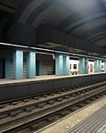
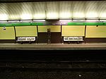
Sant Gervasi is a railway station located under Plaça Molina in the Sarrià-Sant Gervasi district of Barcelona. During off-peak periods it is served by line L6 of the Barcelona Metro. During peak periods, additional services are provided by lines S5 and S55 of the Metro del Vallès commuter rail system, whilst service on line L6 is reduced or removed altogether. All these lines are operated by Ferrocarrils de la Generalitat de Catalunya, who also run the station.The station has twin tracks, with two 80 metres (260 ft) long side platforms. It is located close to Plaça Molina station, on metro line L7. The two stations are connected by a pedestrian tunnel, within the fare paid area of both stations.Due to the renovations at the Gràcia station, commuters wishing to take the L7 line to Avinguda Tibidabo must access it by switching from Sant Gervasi to Plaça Molina.The first Sant Gervasi station opened in 1863 and was situated in a cutting with a station building at ground level. The current station was opened in 1929, when the line serving the station was put underground.

Excerpt from the Wikipedia article Sant Gervasi station (License: CC BY-SA 3.0, Authors, Images).

Sant Gervasi station
Via Augusta, Barcelona

Geographical coordinates (GPS) Address Nearby Places
placeShow on map

Wikipedia: Sant Gervasi stationContinue reading on Wikipedia

Geographical coordinates (GPS)

Latitude Longitude
N 41.401111111111 ° E 2.1472222222222 °
placeShow on map

Address

Via Augusta

Via Augusta
08001 Barcelona (Sarrià - Sant Gervasi)
Catalonia, Spain
mapOpen on Google Maps

DSC 7872 MRMetroBarcelone
Share experience

Nearby Places

Carrer de Balmes, Barcelona

Carrer de Balmes (Catalan pronunciation: [kəˈre ðə ˈβalməs]), named after the Catalan philosopher and ecclesiastic Jaume Balmes, is one of the most important avenues in Barcelona (Catalonia, Spain). It was devised in 1859 as part of Ildefons Cerdà urban plan. Balmes is along Carrer Muntaner the longest road stretching from the sea towards the mountainside. It starts in the crossing of Pelai and Bergara streets and crosses the Eixample and Sant Gervasi districts, ending in Plaça John Fitzgerald Kennedy, by Avinguda del Tibidabo and Tramvia Blau. The Sant Gervasi part of the street was constructed after 1908. It is considered the central street of Eixample, with Dreta de l'Eixample to its right, and Esquerra de l'Eixample to its left. As with most of the other large streets in the area, it is 20 metres wide, with the difference that its sidewalks are less broad than the average. The street is expected to come under an extensive reform project in 2009, which will see its five lanes be reduced to four - one of them reserved for buses and taxis like it is today. The pavements on either side will also be enlarged and trees will be planted to make the busy street more pedestrian-friendly.Carrer de Balmes is also part of the so-called Gaixample, Barcelona's gay village and hosts one of its most famous clubs, Arena. Banc Sabadell is headquartered at the crossing of Carrer de Balmes with Avinguda Diagonal. Pompeu Fabra University owns a building in this street.

Casa Vicens
Casa Vicens

Casa Vicens (Catalan pronunciation: [ˈkazə βiˈsɛns]) is a modernist building situated in the Gràcia neighbourhood of Barcelona. It is the work of architect Antoni Gaudí and is considered to be his first major project. It was built between 1883 and 1885, although Gaudí drew up the initial plans between 1878 and 1880. The work belongs to the orientalist style, similar to Neo-Mudéjar architecture, although interpreted in Gaudí’s own personal way, with a uniqueness that only he knew how to add to his projects. In this work, and for the first time, Gaudí outlined some of his constructive resources that would become regular features throughout the emergence of Modernism. The work was widely discussed when it was built and caused a great sensation among the general public at the time. When the building was constructed, Gràcia was still an independent urban nucleus of Barcelona; it had its own council and was classified as a town, though nowadays it is a district of the city. The original project had a large garden area, in addition to the house, but over time the land was subdivided and sold for the construction of residential buildings. Nowadays, the property has been reduced to the house and a small surrounding area. To take advantage of the space, Gaudí designed three facades, with the house attached by a dividing wall to an adjoining convent. In 1925 an extension of the house was planned, a commission that was offered to Gaudí, which he declined. Instead, he passed it to one of his protégés, Joan Baptista Serra, who built an extension following Gaudí’s original style, with the inclusion of a new facade, resulting in the building being fully detached. The work belongs to Gaudí’s orientalist period (1883-1888), an era in which the architect made a series of works with a distinctly oriental flavour, inspired by the art of the Near and Far East (India, Persia, Japan), as well as Hispanic Islamic art, such as Mudéjar and Nasrid. During this period, Gaudí used an abundance of ceramic tiling to decorate his work, as well as Moorish arches, columns of exposed brick and temple-shaped or dome-shaped finishes. The building was declared a Historic-Artistic Monument in 1969, with registration number 52-MH-EN; an Asset of Cultural Interest in 1993, with reference number RI-51-0003823; and a World Heritage Site in 2005, with reference number 320bis.

El Putxet i el Farró

El Putxet i Farró (not el Putget i el Farró) is a neighbourhood in the Sarrià-Sant Gervasi district of Barcelona, Catalonia (Spain), located on a hill between Vallcarca and Sant Gervasi, urbanised after the 1870s. It is formed by two quarters, the former neighborhoods of el Putxet and el Farró. The primarily residential neighborhood Putxet is named after the hill (elevation 178 m (584 ft)) on which it is located (El turó del Putxet in Catalan meaning the knoll of the hill). The uppermost part of the hill is covered by the public park 'gardens of the hill of Putxet' (Parc del Turó del Putxet in Catalan, see image). This park was inaugurated in 1970 and covers 3.97 hectares. The residential neighbourhood of El Farró is considered by its residents to be very family friendly. Several activities are organized throughout the year in one of its squares, such as food markets, music performances and events for kids during important festivities. The atmosphere is similar to the one of a small town, thanks to its small streets and low buildings. Most of its streets have undergone a renovation in the last few years to become more adapted to pedestrians, eliminating parking spots and considerably reducing the circulating traffic. El Farró is limited by main busy streets and two main squares (Plaça de Lesseps and Plaça Molina), thus making it an oasis in the center of a bustling area of the city. Several transportation options, restaurants and basic stores are available at a very short walking distance. Fans of modernist architecture can find "Cases Ramos" in Plaça de Lesseps, three lesser known but still very impressive modernist apartment buildings, built in 1906 by the architect Jaume Torras i Grau.

Sant Gervasi – Galvany

Sant Gervasi – Galvany is a neighborhood in the Sarrià-Sant Gervasi district of Barcelona, Catalonia (Spain). The name of the neighborhood refers to Sant Gervasi de Cassoles, which was one of the parts of the former municipality of Sant Gervasi de Cassoles; and the Camp d'en Galvany urbanization which was begun in 1866 by its owner, Joseph Galvany Castelló. The Galvany name became popular when the market Galvany was built, located between the neighborhood streets Santaló, Calaf, Amigó and Madrazo, and the market has a plaque on the facade of Santaló street recalling that Josep Galvany Castelló gave the land on which the market was built to the municipality. It occupies the area between Av. Diagonal, Av. de Sarrià, General Mitre, Balmes and Via Augusta. This area corresponds approximately to the neighbourhood of Lledó which took its name from the old Mas Lledó in the division of neighbourhoods approved by the Sant Gervasi town hall in 1879. The population of the neighborhood are mainly of upper class extraction and the oldest part is around the streets of Sagués i Amigó. From the 1950s onwards numerous new buildings have been constructed, the most luxurious of which are to be found in Muntaner street. Today it is a neighborhood with a lively nightlife due to the large number of bars, restaurants and nightspots, especially around Santaló and the surrounding streets. The nearby Turó Park is covered in a separate article in the Spanish Wikipedia.