place

Sung Wong Toi station

Kowloon CityMTR stations in KowloonMa Tau ChungMa Tau WaiSha Tin to Central Link
Tuen Ma lineUse Hong Kong English from May 2021
Platform 2, Sung Wong Toi Station, MTR 20210613

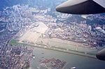
Sung Wong Toi is an underground MTR rapid transit station in Hong Kong on the Tuen Ma line, located in Ma Tau Chung in Kowloon City District. The station also serves Kowloon City and Ma Tau Wai via a pedestrian tunnel. The station was built as part of the Sha Tin to Central Link (SCL), and opened on 27 June 2021 along with the rest of phase 2 of the Tuen Ma line (Sung Wong Toi to Hung Hom). The station was constructed by a Samsung–Hsin Chong joint venture.

Excerpt from the Wikipedia article Sung Wong Toi station (License: CC BY-SA 3.0, Authors, Images).

Sung Wong Toi station
Olympic Avenue, Kowloon Ma Tau Chung (Kowloon City District)

Geographical coordinates (GPS) Address Nearby Places
placeShow on map

Wikipedia: Sung Wong Toi stationContinue reading on Wikipedia

Geographical coordinates (GPS)

Latitude Longitude
N 22.3258 ° E 114.1914 °
placeShow on map

Address

宋皇臺 Sung Wong Toi

Olympic Avenue
Kowloon, Ma Tau Chung (Kowloon City District)
Hong Kong, China
mapOpen on Google Maps

Platform 2, Sung Wong Toi Station, MTR 20210613
Share experience

Nearby Places

Kai Tak Airport
Kai Tak Airport

Kai Tak Airport (IATA: HKG, ICAO: VHHH) was the international airport of Hong Kong from 1925 until 1998. Officially known as Hong Kong International Airport from 1954 to 6 July 1998, it is often referred to as Hong Kong International Airport, Kai Tak, or simply Kai Tak and Kai Tak International Airport, to distinguish it from its successor, which may be referred to as Chek Lap Kok International Airport, built on reclaimed and levelled land around the islands of Chek Lap Kok and Lam Chau, 30 kilometres (19 mi) to the west.Because of the geography of the area positioning the airport with water on three sides of the runway, with Kowloon City's residential apartment complexes and 2000+ft mountains to the north-east of the airport, aircraft could not fly over the mountains and quickly drop in for a final. Instead, aircraft had to fly above Victoria Harbour and Kowloon City, passing north of Mong Kok's Bishop Hill. After passing Bishop Hill, pilots would see Checkerboard Hill with a large red and white checkerboard pattern. Once the pattern was sighted and identified, aircraft made a low-altitude (sub-600 ft) 47° right-hand turn, ending with a short final and touchdown. For pilots, this airport was technically demanding, as the approach could not be flown by aircraft instruments, but had to be flown visually because of the right-hand turn required. The History Channel program Most Extreme Airports ranked it as the 6th most dangerous airport in the world.The airport was home to Hong Kong's international carrier Cathay Pacific, as well as regional carrier Dragonair (now known as Cathay Dragon), freight airline Air Hong Kong and Hong Kong Airways. The airport was also home to the former RAF Kai Tak.