place

Kowloon City District

Kowloon City DistrictUse Hong Kong English from December 2018
HK Kowloon City District 2008

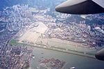
Kowloon City District is one of the 18 districts of Hong Kong. It is located in the city of Kowloon. It had a population of 381,352 in 2001, and increased to 418,732 in 2016. The district has the third most educated residents while its residents enjoy the highest income in Kowloon. It borders all the other districts in Kowloon, with Kwun Tong district to the east, Wong Tai Sin district to its northeast, Sham Shui Po district to its northwest, and Yau Tsim Mong district to its southwest. Kowloon City district covers approximately area of 1,000 hectares, and is mainly a residential area with the majority of its population living in private sector housing, including old tenement buildings, private residential developments and low-rise villas, while the rest of them mainly live in public rental housing and the Home Ownership Scheme estates. It is the only district that incorporated into the land of Hong Kong in different stages (Convention of Peking, Convention for the Extension of Hong Kong Territory and the demolition of the Kowloon Walled City) The district includes many notable areas of Kowloon, such as Ho Man Tin, Hung Hom, Kai Tak Airport, Kowloon Tong, Ma Tau Wai, To Kwa Wan, and Whampoa Garden, and the proper Kowloon City, from where it derives its namesake.

Excerpt from the Wikipedia article Kowloon City District (License: CC BY-SA 3.0, Authors, Images).

Kowloon City District
Prince Edward Road West, Kowloon Kowloon City (Kowloon City District)

Geographical coordinates (GPS) Address Nearby Places
placeShow on map

Wikipedia: Kowloon City DistrictContinue reading on Wikipedia

Geographical coordinates (GPS)

Latitude Longitude
N 22.3282 ° E 114.19155 °
placeShow on map

Address

Prince Edward Road West 456-464
Kowloon, Kowloon City (Kowloon City District)
Hong Kong, China
mapOpen on Google Maps

HK Kowloon City District 2008
Share experience

Nearby Places

Kai Tak Airport
Kai Tak Airport

Kai Tak Airport (IATA: HKG, ICAO: VHHH) was the international airport of Hong Kong from 1925 until 1998. Officially known as Hong Kong International Airport from 1954 to 6 July 1998, it is often referred to as Hong Kong International Airport, Kai Tak, or simply Kai Tak and Kai Tak International Airport, to distinguish it from its successor, which may be referred to as Chek Lap Kok International Airport, built on reclaimed and levelled land around the islands of Chek Lap Kok and Lam Chau, 30 kilometres (19 mi) to the west.Because of the geography of the area positioning the airport with water on three sides of the runway, with Kowloon City's residential apartment complexes and 2000+ft mountains to the north-east of the airport, aircraft could not fly over the mountains and quickly drop in for a final. Instead, aircraft had to fly above Victoria Harbour and Kowloon City, passing north of Mong Kok's Bishop Hill. After passing Bishop Hill, pilots would see Checkerboard Hill with a large red and white checkerboard pattern. Once the pattern was sighted and identified, aircraft made a low-altitude (sub-600 ft) 47° right-hand turn, ending with a short final and touchdown. For pilots, this airport was technically demanding, as the approach could not be flown by aircraft instruments, but had to be flown visually because of the right-hand turn required. The History Channel program Most Extreme Airports ranked it as the 6th most dangerous airport in the world.The airport was home to Hong Kong's international carrier Cathay Pacific, as well as regional carrier Dragonair (now known as Cathay Dragon), freight airline Air Hong Kong and Hong Kong Airways. The airport was also home to the former RAF Kai Tak.