place

Nunhead railway station

DfT Category E stationsFormer London, Chatham and Dover Railway stationsFormer Southern Railway (UK) stationsLondon stations without latest usage statistics 1415London stations without latest usage statistics 1516
NunheadRail transport stations in London fare zone 2Railway stations in Great Britain opened in 1871Railway stations in the London Borough of SouthwarkRailway stations served by SoutheasternThameslink railway stationsUse British English from August 2012
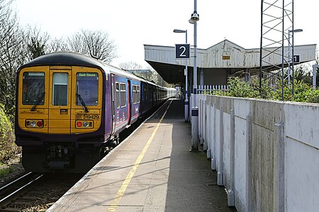
Nunhead Station (geograph 4439124)

Nunhead railway station is in the Nunhead area of the London Borough of Southwark. It is 5 miles 77 chains (9.6 km) measured from London Victoria. The station is managed by Thameslink. It is in Travelcard Zone 2.

Excerpt from the Wikipedia article Nunhead railway station (License: CC BY-SA 3.0, Authors, Images).

Nunhead railway station
Hollydale Road, London Nunhead (London Borough of Southwark)

Geographical coordinates (GPS) Address Website Nearby Places
placeShow on map

Wikipedia: Nunhead railway stationContinue reading on Wikipedia

Geographical coordinates (GPS)

Latitude Longitude
N 51.4671 ° E -0.0527 °
placeShow on map

Address

Hollydale Primary School

Hollydale Road
SE15 2AR London, Nunhead (London Borough of Southwark)
England, United Kingdom
mapOpen on Google Maps

Website
hollydale.southwark.sch.uk

linkVisit website

Nunhead Station (geograph 4439124)
Share experience

Nearby Places

Hatcham
Hatcham

Hatcham was a manor and later a chapelry in what is now London, England. It largely corresponds to the area around New Cross in the London Borough of Lewisham. The ancient parish of Deptford straddled the counties of Surrey and Kent and there came to be a doubt about which county jurisdiction the manor of Hatcham came under. In 1636, the matter was settled by placing it entirely within Surrey. Hatcham became part of Deptford St Paul when the parish was divided in 1730. It has lent its name to the ecclesiastical parishes of All Saints' Hatcham Park, St Catherine's Hatcham, and St James' Hatcham, as the Church of England has thus far avoided the neologism New Cross which came in after the railways were built. In the Domesday Book it is recorded as Hacheham. The name means "home of a man named Hæcci" and derives from an Old English personal name. It is described as a manor containing land for three ploughs, nine villagers and two smallholders, 6 acres (24,000 m2) of meadowland and woodland for 3 pigs. Hatcham formed part of the Brixton Hundred of Surrey in medieval times. The manor was bought by the Haberdashers' Company in 1614, which later demolished the former manor house (during the 1840s) for redevelopment and the foundation of its schools.Hatcham has been included within the Metropolitan Police District since 1830. In 1855 it was included in the area of responsibility of the Metropolitan Board of Works, in the Greenwich District. It became part of the County of London in 1889 and the Metropolitan Borough of Deptford in 1900.Although the place name has largely fallen out of common parlance, its use is retained by several organisations including the Hatcham Liberal Club on Queen's Road and in the names of Haberdashers' Hatcham College. Hatcham also constitutes a conservation area nowadays for planning purposes. The area largely corresponds to the contemporary district known as New Cross Gate.