Fort Carroll
American Civil War on the National Register of Historic PlacesArtificial islands of the United StatesBuildings and structures in Baltimore County, MarylandForts in MarylandForts on the National Register of Historic Places in Maryland ... and 7 more
Infrastructure completed in 1848Landforms of Baltimore County, MarylandNational Register of Historic Places in Baltimore County, MarylandRiver islands of MarylandRobert E. LeeSea fortsUnused buildings in Maryland

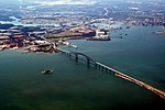
Fort Carroll is a 3.4-acre (1.4 ha) artificial island and abandoned hexagonal sea fort in the middle of the Patapsco River, just south of Baltimore, Maryland. It is named for Charles Carroll of Carrollton (1737–1832), a signer of the Declaration of Independence.
Excerpt from the Wikipedia article Fort Carroll (License: CC BY-SA 3.0, Authors, Images).Fort Carroll
Baltimore Beltway, Dundalk
Geographical coordinates (GPS) Address External links Nearby Places Show on map
Geographical coordinates (GPS)
| Latitude | Longitude |
|---|---|
| N 39.214722222222 ° | E -76.519166666667 ° |
Address
Fort Carroll
Baltimore Beltway
21222 Dundalk
Maryland, United States
Open on Google Maps


