place

Bay Head station

1882 establishments in New JerseyFormer New York and Long Branch Railroad stationsFormer Pennsylvania Railroad stationsNJ Transit Rail Operations stationsRailway stations in Ocean County, New Jersey
Railway stations in the United States opened in 1882Stations on the North Jersey Coast LineUse mdy dates from May 2023
Bay Head station January 2018

Bay Head is a railway station in Bay Head, in Ocean County, New Jersey, United States. The station is served by trains on NJ Transit's North Jersey Coast Line, and it is the southern terminus for the line. The rail yard contains 33 acres (13 ha) of wetland inside the loop formed by the tracks used to turn around the trains. The rail yard borders Twilight Lake. Parking is free at the Bay Head station although the lot is only about a fourth of the size of the lot at the next station, Point Pleasant Beach, which requires payment. This station is not listed as disabled accessible by NJ Transit. Passengers must use the train stairs to climb up to the cars or descend to street level. There is no ramp or platform to aid the handicapped in boarding. Weekend ridership to the Bay Head station rises during the summer as beachgoing vacationers take the train to the beach. In May 2011, ticket vending machines were installed next to the station building at Bay Head.

Excerpt from the Wikipedia article Bay Head station (License: CC BY-SA 3.0, Authors, Images).

Bay Head station
Birch Avenue,

Geographical coordinates (GPS) Address Nearby Places
placeShow on map

Wikipedia: Bay Head stationContinue reading on Wikipedia

Geographical coordinates (GPS)

Latitude Longitude
N 40.076111111111 ° E -74.046388888889 °
placeShow on map

Address

Birch Avenue
08742
New Jersey, United States
mapOpen on Google Maps

Bay Head station January 2018
Share experience

Nearby Places

Point Pleasant Beach, New Jersey

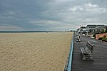
Point Pleasant Beach is a coastal borough situated on the Jersey Shore, and the northernmost community directly facing the Atlantic Ocean within Ocean County, in the U.S. state of New Jersey. It lies at the northern end of the Barnegat Peninsula, which serves as a barrier island separating Barnegat Bay from the open Atlantic Ocean. The borough's name is derived from its location.As of the 2020 United States census, the borough's population was 4,766, an increase of 101 (+2.2%) from the 2010 census count of 4,665, which in turn reflected a decline of 649 (−12.2%) from the 5,314 counted in the 2000 census.Point Pleasant Beach was incorporated as a borough by an act of the New Jersey Legislature on May 18, 1886, from portions of Brick Township, subject to the results of a referendum passed the previous day. Point Pleasant Beach lies immediately to the east of Point Pleasant borough, an entirely separate municipality within Ocean County. The borough's boardwalk is approximately one mile long, spanning the coastline from the Manasquan Inlet at the north to New Jersey Avenue in the south. The central third of the boardwalk is largely amusement rides, the Jenkinson's Aquarium, the Jenkinsons Arcades, pizza joints, ice cream parlors, games-of-chance and miniature golf courses. There are fees of up to $10 per person age 12 or over to access the various beaches, as well as parking fees of up to $2.50 per hour or more.The beach was ranked eighth-best in New Jersey in the "2008 Top 10 Beaches Contest" sponsored by the New Jersey Marine Sciences Consortium.

Mantoloking, New Jersey

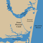
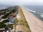
Mantoloking (, MAN-ta-LO-king)) is a coastal borough in Ocean County, in the U.S. state of New Jersey. As of the 2020 United States census, the borough's population was 331, an increase of 35 (+11.8%) from the 2010 census count of 296, which in turn reflected a decline of 127 (−30.0%) from the 423 counted in the 2000 census. The borough has an estimated summer population of approximately 5,000.As of the 2000 census, Mantoloking was the highest-income community in the state of New Jersey with a per capita money income of $114,017 as of 1999, an increase of 29.8% from the $87,830 recorded in 1989. Based on data from the 2006–2010 American Community Survey, the borough had a per-capita income of $97,938, ranked 4th in the state. In the Forbes magazine 2012 rankings of "America's Most Expensive ZIP Codes", the borough was ranked 139th, with a median price of $1,403,349.Mantoloking was incorporated as a borough by an act of the New Jersey Legislature on April 10, 1911, from portions of Brick Township. The name Mantoloking is derived from the Unami language of the Lenni Lenape Native Americans who once inhabited New Jersey. Various meanings have been attributed to the community's name including "frog ground" or "sand place".The borough is a Jersey Shore community situated on the Barnegat Peninsula, also known as Barnegat Bay Island, a long, narrow barrier island that separates Barnegat Bay from the Atlantic Ocean. The town is linked to the New Jersey-mainland via the Mantoloking Bridge, linking the town with Brick Township across the Barnegat Bay. Mantoloking is home to the Olympic-champion producing Mantoloking Yacht Club. Some old "summer cottages" in the borough were designed by architect Stanford White of McKim, Mead & White. Together with Bay Head to the north, Mantoloking is considered part of the Jersey Shore's "Gold Coast". It is a dry town where alcohol is not permitted to be sold by law.