Mantoloking, New Jersey

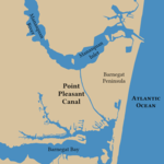
Mantoloking (, MAN-ta-LO-king)) is a coastal borough in Ocean County, in the U.S. state of New Jersey. As of the 2020 United States census, the borough's population was 331, an increase of 35 (+11.8%) from the 2010 census count of 296, which in turn reflected a decline of 127 (−30.0%) from the 423 counted in the 2000 census. The borough has an estimated summer population of approximately 5,000.As of the 2000 census, Mantoloking was the highest-income community in the state of New Jersey with a per capita money income of $114,017 as of 1999, an increase of 29.8% from the $87,830 recorded in 1989. Based on data from the 2006–2010 American Community Survey, the borough had a per-capita income of $97,938, ranked 4th in the state. In the Forbes magazine 2012 rankings of "America's Most Expensive ZIP Codes", the borough was ranked 139th, with a median price of $1,403,349.Mantoloking was incorporated as a borough by an act of the New Jersey Legislature on April 10, 1911, from portions of Brick Township. The name Mantoloking is derived from the Unami language of the Lenni Lenape Native Americans who once inhabited New Jersey. Various meanings have been attributed to the community's name including "frog ground" or "sand place".The borough is a Jersey Shore community situated on the Barnegat Peninsula, also known as Barnegat Bay Island, a long, narrow barrier island that separates Barnegat Bay from the Atlantic Ocean. The town is linked to the New Jersey-mainland via the Mantoloking Bridge, linking the town with Brick Township across the Barnegat Bay. Mantoloking is home to the Olympic-champion producing Mantoloking Yacht Club. Some old "summer cottages" in the borough were designed by architect Stanford White of McKim, Mead & White. Together with Bay Head to the north, Mantoloking is considered part of the Jersey Shore's "Gold Coast". It is a dry town where alcohol is not permitted to be sold by law.
Excerpt from the Wikipedia article Mantoloking, New Jersey (License: CC BY-SA 3.0, Authors, Images).Mantoloking, New Jersey
Barnegat Lane,
Geographical coordinates (GPS) Address Nearby Places Show on map
Geographical coordinates (GPS)
| Latitude | Longitude |
|---|---|
| N 40.056688 ° | E -74.04816 ° |
Address
Barnegat Lane 920
08738
New Jersey, United States
Open on Google Maps


