place

Point Pleasant Canal
Canals in New JerseyCanals opened in 1925Intracoastal WaterwayNew Jersey transportation stubsTransportation buildings and structures in Ocean County, New Jersey
PointPlesantCanal
PointPlesantCanal

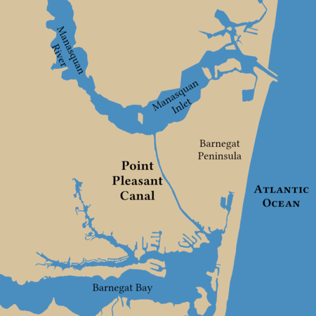
The Point Pleasant Canal is a canal in Point Pleasant, New Jersey. It was completed in 1925 to connect the Manasquan Inlet and Manasquan River with Bay Head Harbor on the northern end of Barnegat Bay. The canal is part of the Intracoastal Waterway. With the completion of the canal, the Barnegat Peninsula effectively became an island. The island is connected to the mainland by two lift bridges spanning the canal; as well as three bridges to the south which cross the Barnegat Bay. The bridges, at Route 88, at Bridge Avenue (the Lovelandtown Bridge), at Mantoloking Road (the Mantoloking Bridge), and two bridges at Route 37 (the Thomas A. Mathis Bridge and the J. Stanley Tunney Bridge), open on demand, halting motor traffic to allow boats to pass underneath as marine traffic has the right of way.

Excerpt from the Wikipedia article Point Pleasant Canal (License: CC BY-SA 3.0, Authors, Images).

Point Pleasant Canal
North Road,

Geographical coordinates (GPS) Address Nearby Places
placeShow on map

Wikipedia: Point Pleasant CanalContinue reading on Wikipedia

Geographical coordinates (GPS)

Latitude Longitude
N 40.0784 ° E -74.0645 °
placeShow on map

Address

North Road 2049
08742
New Jersey, United States
mapOpen on Google Maps

PointPlesantCanal
PointPlesantCanal
Share experience

Nearby Places

Point Pleasant Beach, New Jersey

Point Pleasant Beach is a coastal borough situated on the Jersey Shore, and the northernmost community directly facing the Atlantic Ocean within Ocean County, in the U.S. state of New Jersey. It lies at the northern end of the Barnegat Peninsula, which serves as a barrier island separating Barnegat Bay from the open Atlantic Ocean. The borough's name is derived from its location.As of the 2020 United States census, the borough's population was 4,766, an increase of 101 (+2.2%) from the 2010 census count of 4,665, which in turn reflected a decline of 649 (−12.2%) from the 5,314 counted in the 2000 census.Point Pleasant Beach was incorporated as a borough by an act of the New Jersey Legislature on May 18, 1886, from portions of Brick Township, subject to the results of a referendum passed the previous day. Point Pleasant Beach lies immediately to the east of Point Pleasant borough, an entirely separate municipality within Ocean County. The borough's boardwalk is approximately one mile long, spanning the coastline from the Manasquan Inlet at the north to New Jersey Avenue in the south. The central third of the boardwalk is largely amusement rides, the Jenkinson's Aquarium, the Jenkinsons Arcades, pizza joints, ice cream parlors, games-of-chance and miniature golf courses. There are fees of up to $10 per person age 12 or over to access the various beaches, as well as parking fees of up to $2.50 per hour or more.The beach was ranked eighth-best in New Jersey in the "2008 Top 10 Beaches Contest" sponsored by the New Jersey Marine Sciences Consortium.