Point Pleasant, New Jersey

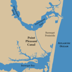
Point Pleasant is a borough situated on the Jersey Shore, in northern Ocean County, in the U.S. state of New Jersey. As of the 2020 United States census, the borough's population was 18,941, an increase of 549 (+3.0%) from the 2010 census count of 18,392, which in turn reflected a decline of 914 (−4.7%) from the 19,306 counted at 2000 census.The borough is a Jersey Shore community situated south of the Manasquan River and north and east of the Beaverdam Creek and its confluence with the Metedeconk River. Point Pleasant was incorporated as a borough by an act of the New Jersey Legislature on April 21, 1920, from portions of Brick Township, based on the results of a referendum held on May 19, 1920. The borough was reincorporated on March 12, 1928. Point Pleasant is distinct from Point Pleasant Beach, which is a separate community. The borough gets its name from Point Pleasant Beach, which gets its name from its location at the northern end of the Barnegat Peninsula, a long, narrow barrier peninsula that divides the Barnegat Bay from the Atlantic Ocean at the Manasquan Inlet.
Excerpt from the Wikipedia article Point Pleasant, New Jersey (License: CC BY-SA 3.0, Authors, Images).Point Pleasant, New Jersey
Old Driveift Road,
Geographical coordinates (GPS) Address Nearby Places Show on map
Geographical coordinates (GPS)
| Latitude | Longitude |
|---|---|
| N 40.077748 ° | E -74.069921 ° |
Address
Old Driveift Road
Old Driveift Road
08742
New Jersey, United States
Open on Google Maps


