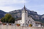
Saint-Hilaire, Isère

Saint-Hilaire (), also known as Saint-Hilaire-du-Touvet (French pronunciation: [sɛ̃t‿ilɛːʁ dy tuvɛ]), is a former commune in the Isère department in the Auvergne-Rhône-Alpes region in Southeastern France. On 1 January 2019, Saint-Hilaire was merged into the new commune of Plateau-des-Petites-Roches, alongside Saint-Bernard and Saint-Pancrasse. The commune was made up of the three smaller settlements of Saint-Hilaire, Les Margains and Les Gaudes; its town hall became that of the new commune. Its inhabitants are known in French as the Saint-Hilairois (masculine) and Saint-Hilairoises (feminine).It is situated on the Plateau des Petites Roches, a natural balcony above the valley of the Isère, on the east side of the Massif de la Chartreuse and overlooked by the peak of the Dent de Crolles.
Excerpt from the Wikipedia article Saint-Hilaire, Isère (License: CC BY-SA 3.0, Authors, Images).Saint-Hilaire, Isère
Chemin de la Chapelle, Grenoble
Geographical coordinates (GPS) Address Website Nearby Places Show on map
Geographical coordinates (GPS)
| Latitude | Longitude |
|---|---|
| N 45.3103 ° | E 5.8878 ° |
Address
Chemin de la Chapelle
38660 Grenoble
Auvergne-Rhône-Alpes, France
Open on Google Maps


