place

Stoke Holy Cross

Civil parishes in NorfolkTransmitter sites in EnglandUse British English from July 2019Villages in Norfolk
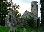
Holy Cross Church geograph.org.uk 1352087

Stoke Holy Cross is a village in South Norfolk which lies approximately 4 miles (6.4 km) south of Norwich.

Excerpt from the Wikipedia article Stoke Holy Cross (License: CC BY-SA 3.0, Authors, Images).

Stoke Holy Cross
Colman Avenue, South Norfolk Stoke Holy Cross

Geographical coordinates (GPS) Address Nearby Places
placeShow on map

Wikipedia: Stoke Holy CrossContinue reading on Wikipedia

Geographical coordinates (GPS)

Latitude Longitude
N 52.5693 ° E 1.29738 °
placeShow on map

Address

Colman Avenue

Colman Avenue
NR14 8NA South Norfolk, Stoke Holy Cross
England, United Kingdom
mapOpen on Google Maps

Holy Cross Church geograph.org.uk 1352087
Share experience

Nearby Places

Caistor St Edmund
Caistor St Edmund

Caistor St Edmund is a village and former civil parish on the River Tas, now in the parish of Caistor St Edmund and Bixley, South Norfolk, England. The parish covered an area of 6.55 square kilometres (2.53 sq mi) and had a population of 270 in 116 households at the 2001 census, the population increasing to 289 at the 2011 Census. On the 1st of April 2019 the parish was merged with Bixley to form Caistor St Edmund and Bixley.The remains of a Roman market town and capital of the Iceni tribe, Venta Icenorum, are nearby (British National Grid ref TG230034). The ruins are in the care of the Norfolk Archaeological Trust and managed by South Norfolk Council. It is assumed that the Roman 'Stone Street' runs from Dunwich on the Suffolk coast to Caistor St Edmund. The parish church of St Edmund's lies at the south-east corner of the old Roman town. Caistor St Edmund features on the Antonine Itinerary, a Roman "road map" of the routes around Britain. The villages name means 'Roman site'. The church is dedicated to St. Edmund hence that addition to distinguish it from Caister-on-Sea. Caistor Old Hall was built in 1612 for Thomas Pettus. During the 19th century it was owned by John Spurrell (son of William Spurrell, of Thurgarton, Norfolk). The River Tas passes under Markshall bridge, just north of the Roman camp, and then flows on towards Arminghall and Trowse. The village has one hotel, Caistor Hall Hotel, a fine example of Georgian building constructed between 1795 and 1797 by the Dashwood family. The actual site can be traced back even further to before the Norman Conquest and originally belonged to the Abbey at Bury St Edmunds until it was confiscated during the Dissolution of the Monasteries. Caistor Manor and land then passed to the Godslave family who owned it until the early 1600s and then in turn to the Pettus family. Through marriage the land became the property of the Dashwoods in 1793. The first recorded owner was Horatio Dashwood who lived in the hall with his wife Harriet and their children.

Keswick, South Norfolk

Keswick is a village in the civil parish of Keswick and Intwood, in Norfolk, England. It is situated some 3 miles (4.8 km) to the south of the city of Norwich. It should not be mistaken for the coastal settlement of Keswick, near Bacton, which is also in Norfolk.[1]The civil parish has an area of 5.52 km2 (2.13 sq mi) and in the 2001 census had a population of 431 in 248 households, the population increasing to 444 at the 2011 census. For the purposes of local government, the parish falls within the district of South Norfolk.[2]The church of Keswick All Saints is one of 124 existing round-tower churches in Norfolk. There was a small early church here, but it was demolished c 1598 to use the materials to repair Intwood’s round-tower church, when the two parishes were consolidated. The original east wall of the chancel still stands to the east of the existing church, and part of the tower could also be Saxon, although it was much repaired in 1893. At that time the short nave was added to the tower to make a mortuary chapel. In 1934 church services were authorised, but the apse was not added until some decades later.Keswick Hall near All Saints was the representative manor and country house that served as a residence of the Gurney family. Between 1948 and 1981 it accommodated a teacher training college (which was then incorporated into the University of East Anglia) prior to being converted into apartments. Several members of the Gurneys of Keswick are buried in the churchyard of All Saints.Former professional footballer Darren Huckerby lives in the village.