place

Camp Fitzgerald

1861 disestablishments in California1861 establishments in California19th century in Los AngelesAmerican Civil War forts and army posts in CaliforniaHistory of Los Angeles
Military installations closed in 1861Military installations established in 1861
Flag of the United States of America (1861–1863)

Before Camp Latham or Camp Drum existed in the District of Southern California during the American Civil War there was Camp Fitzgerald, located somewhere near downtown Los Angeles. Camp Fitzgerald was organized sometime after May 3 and before October 1861 by James H. Carleton out of Fort Tejon. Camp Fitzgerald was named for Edward H. Fitzgerald, a U.S. Army Major who had himself established Fort Jones but had died of consumption in January 1860. The New York Times mentioned the establishment of the camp, which then had four companies of men, on July 31, 1861: "...four companies of United States regulars were recalled from neighboring stations, and now occupy tents fronting the city named."However Camp Fitzgerald was in a disadvantageous location for a "permanent camp and supply base," not least because of the distance from the port at San Pedro. Camp Fitzgerald was apparently relocated three times in hopes of finding better water and pasture for the horses but an ideal site was never found and Camp Fitzgerald, like Camp Latham, was eventually closed in favor of the Drum Barracks site which ultimately became the headquarters of the Army of the Pacific in southern California. Camp Fitzgerald likely lasted for less than a year, if that, but the exact date of closure is unclear.

Excerpt from the Wikipedia article Camp Fitzgerald (License: CC BY-SA 3.0, Authors, Images).

Camp Fitzgerald
East 48th Street,

Geographical coordinates (GPS) Address Nearby Places
placeShow on map

Wikipedia: Camp FitzgeraldContinue reading on Wikipedia

Geographical coordinates (GPS)

Latitude Longitude
N 34.0005 ° E -118.2317 °
placeShow on map

Address

East 48th Street 2316
90058
California, United States
mapOpen on Google Maps

Flag of the United States of America (1861–1863)
Share experience

Nearby Places

Clement Junction, California

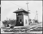
Clement Junction, CA (elev. 217' MSL) is a populated place (US Census Class Code U6; Location #1660495) located in Los Angeles County, California, at latitude 34º00'50" N and longitude 118º14'20" W, and appears as a named place on the U.S. Geological Survey Los Angeles 7.5' Topographical Quadrangle Map. The community derives its name from the major railroad junction situated there which was named for Canadian-born civil engineer and surveyor Lewis Metzler Clement (1837-1914), Chief Assistant Engineer (later Acting Chief Engineer) and Superintendent of Track of the Central Pacific Railroad Company of California (1862–81). At that location the Southern Pacific Railroad main line (MP 485.4) to Los Angeles via the San Joaquin Valley from Northern California (opened in 1876) joined with the rails of the already existing 22-mile Los Angeles & San Pedro Railroad which the SP had acquired in 1874, and thus established a rail link to San Francisco, Sacramento, and the East via the Pacific Railroad (CPRR/UPRR). Opened in 1869 to provide rail service for the Port of Los Angeles, the LA&SPRR was the first railroad built in Southern California. Now primarily an industrial area, Clement Junction is located approximately three miles due South of Los Angeles City Hall and two miles due East of the Los Angeles Memorial Coliseum. The Union Pacific Railroad acquired the tracks of the railroad junction (along with its associated freight yard and sidings) in 1996 when it merged with the Southern Pacific Transportation Company, although the former SP Santa Monica Branch, which once connected at the junction, had been abandoned in 1989.

Linda Esperanza Marquez High School

Linda Esperanza Marquez High School (or simply Marquez High School) is a public choice high school in Huntington Park, California that is part of the Los Angeles Unified School District. Marquez High School opened in 2013 as part of LA Unified's $19.5 billion New School Construction and Modernization Program. The school is a Choice site that offers the LIBRA Academy, The Huntington Park Institute of Applied Medicine, and the School of Social Justice. The campus was designed by Ehrlich Architects (a Culver City firm that won the 2015 AIA Architecture Firm Award) on a 14-acre industrial site, near a freight rail tunnel and a sawmill. Ehrlich first presented the design in 2005, and construction lasted seven years. The Huntington Park community had initially expressed a preference for a Mediterranean style building similar to the city hall building, but the contemporary design was ultimately approved after community review. Designed for 1,620 students, the facility includes a classroom building with separate floors for each of the three schools, with shared facilities around the other sides, all connected by an "internal pedestrian street". The athletic facilities and library are designed to provide community access when not in use by the school.The site of the school was previously used as a storage yard for used tires, then became a building materials recycling facility that drew community opposition, especially after it was used to store some 600,000 tons of concrete ruins (standing some 60 feet high) from a portion of the Santa Monica Freeway that collapsed in the 1994 Northridge earthquake. Linda Esperanza Marquez, for whom the school is named, is a community activist who fought to have the site (which she called the "mountain of death") cleared and reused.