Sangiano
Cities and towns in LombardyMunicipalities of the Province of VareseProvince of Varese geography stubs

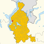
Sangiano is a comune (municipality) in the Province of Varese in the Italian region Lombardy, located about 60 kilometres (37 mi) northwest of Milan and about 15 kilometres (9 mi) northwest of Varese. As of 31 December 2004, it had a population of 1,345 and an area of 2.2 square kilometres (0.85 sq mi).Sangiano borders the following municipalities: Besozzo, Caravate, Laveno-Mombello, Leggiuno. In the area of Sangiano there's a limestone rock wall called "falesia del Picuz" prepared for sport climbing with fixed bolts and belays.
Excerpt from the Wikipedia article Sangiano (License: CC BY-SA 3.0, Authors, Images).Sangiano
Via Luigi Cadorna, Unione dei comuni del Medio Verbano
Geographical coordinates (GPS) Address Nearby Places Show on map
Geographical coordinates (GPS)
| Latitude | Longitude |
|---|---|
| N 45.866666666667 ° | E 8.6333333333333 ° |
Address
Via Luigi Cadorna
21038 Unione dei comuni del Medio Verbano
Lombardy, Italy
Open on Google Maps


