Leith Hill

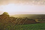
Leith Hill in southern England is the highest summit of the Greensand Ridge, approximately 6.7 km (4 mi) southwest of Dorking, Surrey and 40.5 km (30 mi) southwest of central London. It reaches 294 m (965 ft) above sea level, and is the second highest point in southeast England, after Walbury Hill in southwest Berkshire, (which is 297 m (974 ft) high). Leith Hill is the highest ground for 79 km (49 mi). Four areas of woodland surrounding the hill comprise the 337.9-hectare (835-acre) Leith Hill Site of Special Scientific Interest, although the summit is excluded from this designation.The nearest railway station is Holmwood station, 3.6 km (2 mi) to the east, served by Southern trains to London Victoria.
Excerpt from the Wikipedia article Leith Hill (License: CC BY-SA 3.0, Authors, Images).Leith Hill
Coldharbour Common Road, Mole Valley
Geographical coordinates (GPS) Address Nearby Places Show on map
Geographical coordinates (GPS)
| Latitude | Longitude |
|---|---|
| N 51.175833333333 ° | E -0.36972222222222 ° |
Address
Coldharbour Common Road
RH5 6LX Mole Valley
England, United Kingdom
Open on Google Maps


