place

Willow Tree Fen

Lincolnshire Wildlife TrustLocal Nature Reserves in LincolnshireTourist attractions in LincolnshireUse British English from February 2020
Willow tree fen
Willow tree fen

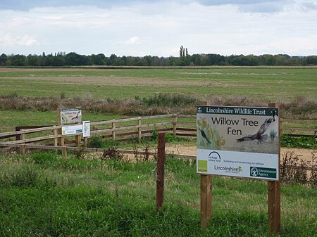
Willow Tree Fen is a local nature reserve with an area of over 112.0 ha (277 acres) located near Bourne and Spalding, south of the River Glen, England. The site was acquired by Lincolnshire Wildlife Trust in 2009 and converted from an arable field into a wetland fen.

Excerpt from the Wikipedia article Willow Tree Fen (License: CC BY-SA 3.0, Authors, Images).

Willow Tree Fen
Slipe Drove, South Holland

Geographical coordinates (GPS) Address Website Nearby Places
placeShow on map

Wikipedia: Willow Tree FenContinue reading on Wikipedia

Geographical coordinates (GPS)

Latitude Longitude
N 52.776379 ° E -0.2506638 °
placeShow on map

Address

Willow Tree Fen Nature Reserve

Slipe Drove
PE10 0BD South Holland
England, United Kingdom
mapOpen on Google Maps

Website
lincstrust.org.uk

linkVisit website

Willow tree fen
Willow tree fen
Share experience

Nearby Places

Gilbert Heathcote's tunnel

Gilbert Heathcote's tunnel was an engineering project dating from the 1630s as one of the earliest modern attempts to drain The Fens in Lincolnshire. Rendered obsolete by the mechanical drainage improvements after World War II, it was finally removed in 1991. It carried water, under gravity, from Bourne South Fen, Thurlby Fen and Northorpe Fen to the Counter Drain and thence to Deeping Fen. A tunnel was required under the River Glen which was (and still is) artificially banked with a level some 3 metres above the surrounding lands and above the Counter Drain. The Counter Drain was pumped further downstream by wind-driven machinery, erected later. At the time of construction Deeping Fen was still inundated. In 1871 the Bourne South Fen Drainage District was formed to take over the drainage, which had been in the hands of adventurers, and from 1872 a succession of steam engines were used to assist the flow through the tunnel.The location is around 500m upstream on the Glen of the confluence with the Bourne Eau. Tongue End is the nearest settlement. The modern by-road alongside the original drain to the tunnel is still called Tunnel Bank. The Gilbert Heathcote for whom it is named appears to be the grandfather of Sir Gilbert Heathcote, 1st Baronet, and an ancestor of the first Baron Aveland. That family later inherited nearby Grimsthorpe Castle, but must have had land and associations with this area to claim the title of Aveland. The area drained falls within the area of the Welland and Deepings Internal Drainage Board.

Deeping Fen
Deeping Fen

Deeping Fen is a low-lying area in the South Holland district of Lincolnshire, England, which covers approximately 47 square miles (120 km2). It is bounded by the River Welland and the River Glen, and is extensively drained, but the efficient drainage of the land exercised the minds of several of the great civil engineers of the 17th and 18th centuries. Drainage schemes were first authorised during the reign of Queen Elizabeth I, but from 1632, a group of adventurers took control of the drainage, in return for which they were granted land. They faced the problem that the outfalls of the River Welland and the River Glen were not sufficiently low to enable proper drainage by gravity, and most schemes included improvement to the rivers. John Perry, an engineer of some repute, who had set the standard for engineering reports in 1727, began work in 1730, and was followed by John Grundy, Sr., a pioneer in applying scientific principles to civil engineering problems. His son, John Grundy, Jr., was another capable engineer, who was retained as a consultant after he resigned as full-time Surveyor of Works. In 1800 the civil engineers William Jessop and John Rennie assisted local engineers with plans for improvements, the chief of which was for a steam pumping station. This plan was not implemented immediately, but two steam engines fitted with scoop wheels were installed at Pode Hole in 1823. The pumping station was the largest in the Fens at the time, and remained so for many years. Steam gradually gave way to diesel engines and scoop wheels were replaced by centrifugal pumps, and the diesel engines were then replaced by electric motors. However, the beam engine and scoop wheel at Pinchbeck Marsh, which ran from 1833 to 1952, was not scrapped, and can be visited by the public. From 1801 the fen was managed by trustees, appointed under the terms of an act of Parliament obtained in that year, and this remained the case until 1939 when the administrative structure was replaced by the Welland & Deepings Internal Drainage Board.