place

Wallis Wood

Surrey Wildlife Trust
Pond in Walliswood Nature Reserve geograph.org.uk 162886

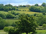
Wallis Wood is a 14-hectare (35-acre) nature reserve south-east of Ewhurst in Surrey. It is managed by the Surrey Wildlife Trust.A stream runs through this woodland reserve, which has an area of meadow pasture on its bank. Woodland flora include bluebells, broad-leaved helleborine orchids, violet helleborine orchids, common spotted orchids, primroses and wood anemone. There is a rare spider, Hyptiotes paradoxus, which lives in yew trees and is only found in one other site in the county.There is access from Horsham Road in Walliswood.

Excerpt from the Wikipedia article Wallis Wood (License: CC BY-SA 3.0, Authors, Images).

Wallis Wood
Green Lane, Mole Valley Abinger

Geographical coordinates (GPS) Address Website External links Nearby Places
placeShow on map

Wikipedia: Wallis WoodContinue reading on Wikipedia

Geographical coordinates (GPS)

Latitude Longitude
N 51.138 ° E -0.399 °
placeShow on map

Address

Wallis Wood

Green Lane
RH5 5QX Mole Valley, Abinger
England, United Kingdom
mapOpen on Google Maps

Website
surreywildlifetrust.org

linkVisit website

linkWikiData (Q60255406)
linkOpenStreetMap (666653111)

Pond in Walliswood Nature Reserve geograph.org.uk 162886
Share experience

Nearby Places

Stane Street (Chichester)

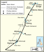
Stane Street is the modern name of the 91 km-long (57 mi) Roman road in southern England that linked Londinium (London) to Noviomagus Reginorum (Chichester). The exact date of construction is uncertain; however, on the basis of archaeological artefacts discovered along the route, it was in use by 70 AD and may have been built in the first decade of the Roman occupation of Britain (as early as 43–53 AD). Stane Street shows clearly the engineering principles that the Romans used when building roads. A straight-line alignment from London Bridge to Chichester would have required steep crossings of the North Downs, Greensand Ridge and South Downs. The road was therefore designed to exploit a natural gap in the North Downs cut by the River Mole and to pass to the east of the high ground of Leith Hill, before following flatter land in the River Arun valley to Pulborough. The direct survey line was followed only for the northernmost 20 km (12 mi) from London to Ewell. At no point does the road lie more than 10 km (6 mi) from the direct line from London Bridge to Chichester. Today the Roman road is easily traceable on modern maps. Much of the route is followed by the A3, A24, A29 and A285, although most of the course through the modern county of Surrey has either been completely abandoned or is followed only by bridlepaths. Earthworks associated with the road are visible in many places where the course is not overlain by modern roads. Several parts of Stane Street are listed as scheduled monuments, including the well-preserved section from Mickleham Downs to Thirty Acres Barn, Ashtead.