place

Smokejack Clay Pit

Geological Conservation Review sitesGeology of South-East EnglandSites of Special Scientific Interest in Surrey
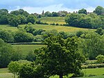
Remains of Ewhurst Brickworks geograph.org.uk 852018

Smokejack Clay Pit is a 56-hectare (140-acre) geological Site of Special Scientific Interest east of Cranleigh in Surrey. It is a Geological Conservation Review site.This site exposes Lower Cretaceous rocks of the Weald Clay Group, which have been studied since 1983. Fossils of six orders of insects have been recorded and an unusual level of details has been preserved. It is the best Weald Clay reptile site, with crocodile teeth, coprolites and part of an Iguanodon. The holotype specimen of the fish eating theropod dinosaur, Baryonyx walkeri was discovered on the site in January 1983.

Excerpt from the Wikipedia article Smokejack Clay Pit (License: CC BY-SA 3.0, Authors, Images).

Smokejack Clay Pit
Horsham Road, Mole Valley Abinger

Geographical coordinates (GPS) Address Nearby Places
placeShow on map

Wikipedia: Smokejack Clay PitContinue reading on Wikipedia

Geographical coordinates (GPS)

Latitude Longitude
N 51.125 ° E -0.415 °
placeShow on map

Address

Horsham Road
RH5 5RL Mole Valley, Abinger
England, United Kingdom
mapOpen on Google Maps

Remains of Ewhurst Brickworks geograph.org.uk 852018
Share experience

Nearby Places

Stane Street (Chichester)

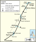
Stane Street is the modern name of the 91 km-long (57 mi) Roman road in southern England that linked Londinium (London) to Noviomagus Reginorum (Chichester). The exact date of construction is uncertain; however, on the basis of archaeological artefacts discovered along the route, it was in use by 70 AD and may have been built in the first decade of the Roman occupation of Britain (as early as 43–53 AD). Stane Street shows clearly the engineering principles that the Romans used when building roads. A straight-line alignment from London Bridge to Chichester would have required steep crossings of the North Downs, Greensand Ridge and South Downs. The road was therefore designed to exploit a natural gap in the North Downs cut by the River Mole and to pass to the east of the high ground of Leith Hill, before following flatter land in the River Arun valley to Pulborough. The direct survey line was followed only for the northernmost 20 km (12 mi) from London to Ewell. At no point does the road lie more than 10 km (6 mi) from the direct line from London Bridge to Chichester. Today the Roman road is easily traceable on modern maps. Much of the route is followed by the A3, A24, A29 and A285, although most of the course through the modern county of Surrey has either been completely abandoned or is followed only by bridlepaths. Earthworks associated with the road are visible in many places where the course is not overlain by modern roads. Several parts of Stane Street are listed as scheduled monuments, including the well-preserved section from Mickleham Downs to Thirty Acres Barn, Ashtead.

Sayers Croft

Sayers Croft is a large outdoor 'learning camp' located in the village of Ewhurst, Surrey. It is one of the few remaining 'Camp schools' built by the National Camps Corporation in 1939 to provide fresh air and fun activities for inner city children and offer a refuge for civilian evacuees in the event of war breaking out. The first occupants of the centre were children from Catford Central and Browhill schools in East London who arrived in May 1940, as the construction work was being completed. The boys, supplemented from other schools as World War II continued, lived at the Centre throughout the war. After the war, the centre was used to rehabilitate Dutch children following the Nazi occupation of the Netherlands. Sayers Croft began taking groups of children from London on residential visits. The National Camps Corporation was not a success, its assets were subsequently transferred to local authorities. The Centre transferred to the Greater London Council, and was run until 1990 by the Inner London Education Authority. Ownership was later transferred to Westminster City Council, who still run the centre. In 1996, The Sayers Croft Trust was established as an independent charity with the aim of involving the local community, especially young people, in the enjoyment and care of the environment. By working in partnership with the Sayers Croft field centre, the Trust aims to make all the facilities of Sayers Croft available to those who may otherwise be unable to access them due to physical, financial or social disadvantage. Sayer's Croft nature reserve on land owned by the centre is a Local Nature Reserve.Over half a million people have visited Sayers Croft. The centre hosts 12,000 visitors annually, from a variety of sources. There is a day visit programme for local schools and a community programme that targets disadvantaged young people. Sayers Croft provides a wide range of opportunities for first hand outdoor learning in a safe environment.