Hazerswoude-Dorp
Alphen aan den RijnPages with non-numeric formatnum argumentsPopulated places in South HollandSouth Holland geography stubs

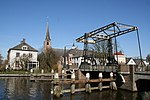
Hazerswoude-Dorp is a village in the west of the Netherlands. It is located in the municipality of Alphen aan den Rijn, South Holland, about 7 km southwest of the town of Alphen aan den Rijn. Hazerswoude-Dorp is a peat excavation settlement which developed in the Middle Ages. It turned into a linear settlement along the dike on the Oude Rijn. A circular canal was dug around the view to prevent a prolapse of the village.The Dutch Reformed church is a single aisled cruciform church. The tower dates from 1646 as a replacement of its medieval predecessor. The church itself was built in 1658.
Excerpt from the Wikipedia article Hazerswoude-Dorp (License: CC BY-SA 3.0, Authors, Images).Hazerswoude-Dorp
Margaretha van Oostenrijklaan, Alphen aan den Rijn
Geographical coordinates (GPS) Address Nearby Places Show on map
Geographical coordinates (GPS)
| Latitude | Longitude |
|---|---|
| N 52.096111111111 ° | E 4.5877777777778 ° |
Address
Margaretha van Oostenrijklaan 21
2391 DC Alphen aan den Rijn
South Holland, Netherlands
Open on Google Maps


