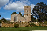
Evenlode

Evenlode is a village and civil parish (ONS Code 23UC051) in the Cotswold District of eastern Gloucestershire in England.Evenlode is bordered by the Gloucestershire parishes of Moreton-in-Marsh to the northwest, Longborough and Donnington to the west, Broadwell to the southwest, and Adlestrop to the southeast; and by the Oxfordshire parish of Chastleton to the east.At Evenlode's northern tip is the Four shire stone, whose name predates the parish's 1931 transfer from Worcestershire; here at a point between Moreton-in-Marsh and Chastleton are the Warwickshire parishes of Little Compton and Great Wolford, as well as Batsford in Gloucestershire. At its southern tip, between Broadwell and Adlestrop, Evenlode meets the parish of Oddington at a point.
Excerpt from the Wikipedia article Evenlode (License: CC BY-SA 3.0, Authors, Images).Evenlode
Horn Lane, Cotswold District Evenlode
Geographical coordinates (GPS) Address Nearby Places Show on map
Geographical coordinates (GPS)
| Latitude | Longitude |
|---|---|
| N 51.961 ° | E -1.669 ° |
Address
Horn Lane
Horn Lane
GL56 0NT Cotswold District, Evenlode
England, United Kingdom
Open on Google Maps


