place

Crouch and Roach Estuaries

Sites of Special Scientific Interest in EssexSpecial Protection Areas in England
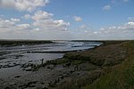
Paglesham Creek, Paglesham Churchend geograph.org.uk 942589

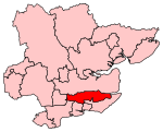
The Crouch and Roach Estuaries are a 1729 hectare biological Site of Special Scientific Interest (SSSI) at the mouth of the Crouch and Roach rivers in Essex. The Crouch part of the SSSI stretches from near Battlesbridge to Foulness Island, and the Roach from Rochford to the junction with the Crouch. Part of the site is in the Mid-Essex Coast Special Protection Area under the EC Directive on the Conservation of Wild Birds, and a Ramsar wetland site of international importance. It is also part of the Essex Estuaries Special Area of Conservation. An area of 65 hectares is managed by the Essex Wildlife Trust as the Lion Creek and Lower Raypits nature reserve and 8 hectares at Woodham Fen, both of which are managed by the Essex Wildlife Trust. A small area is also a geological SSSI, The Cliff, Burnham-on-Crouch.The site has salt marsh, intertidal mud, grazing marsh and a fresh water reservoir. The salt marsh has scarce species including lax-flowered sea-lavender and one-flowered glasswort. Rough grass has dense populations of the nationally scarce Roesel's bush-cricket. The site is internationally important for wintering dark-bellied brent geese, and nationally important for black-tailed godwits, shelducks and shoveller ducks. There are Red Data Book species of invertebrates such as the ground lackey moth.

Excerpt from the Wikipedia article Crouch and Roach Estuaries (License: CC BY-SA 3.0, Authors, Images).

Crouch and Roach Estuaries
Blue House Farm Path to Bird Hides, Essex

Geographical coordinates (GPS) Address Nearby Places
placeShow on map

Wikipedia: Crouch and Roach EstuariesContinue reading on Wikipedia

Geographical coordinates (GPS)

Latitude Longitude
N 51.638 ° E 0.699 °
placeShow on map

Address

Blue House Farm Path to Bird Hides

Blue House Farm Path to Bird Hides
CM3 6NA Essex, Purleigh
England, United Kingdom
mapOpen on Google Maps

Paglesham Creek, Paglesham Churchend geograph.org.uk 942589
Share experience

Nearby Places

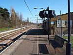
North Fambridge railway station

North Fambridge railway station is on the Crouch Valley Line in the East of England, serving the village of North Fambridge, Essex. It is 37 miles 27 chains (60.09 km) down the line from London Liverpool Street and is situated between South Woodham Ferrers to the west and Althorne to the east. The Engineer's Line Reference for the line is WIS; the station's three-letter station code is NFA. The southern (westbound) platform has an operational length for eight-coach trains while the northern (eastbound) platform can accommodate nine coaches.The line and station were opened for goods on 1 June 1889 and to passenger services on 1 October 1889 by the Great Eastern Railway. Facilities then included two platforms, both provided with buildings and linked by a footbridge; a goods yard including cattle pens; and a 30-lever signal box, reduced to 10 after 1966. The signal box was taken out of use on 1 December 1985 and demolished in February 1986. The original footbridge was replaced with a higher one prior to the electrification of the line in 1986. Electrification using 25 kV overhead line electrification (OLE) was completed on 12 May 1986. North Fambridge station is currently managed by Greater Anglia, which also operates all trains serving it. The typical off-peak service is of one westbound train every 40 minutes to Wickford and one eastbound train every 40 minutes to Southminster, with additional services at peak times. Some peak services continue to or from Shenfield and/or London Liverpool Street via the Great Eastern Main Line. As North Fambridge is at the midpoint of this single-track line, its double-track configuration provides a passing loop to allow two trains to run on the line at any one time. The station was originally called Fambridge (with the code FAM) but this was changed to North Fambridge on 20 May 2007.