Daventry District
2021 disestablishments in EnglandDaventry DistrictFormer non-metropolitan districts of NorthamptonshireWest Northamptonshire District

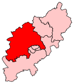
Daventry District was a local government district in western Northamptonshire, England, from 1974 to 2021. The district was named after its main town of Daventry, where the council was based. The district was created on 1 April 1974, under the Local Government Act 1972, by a merger of the historic municipal borough of Daventry with the Daventry Rural District and most of the Brixworth Rural District. The town of Daventry became an unparished area with Charter Trustees and remained so until 2003 when a civil parish was created, roughly corresponding with the boundaries of the former borough, so allowing Daventry to have its own town council.
Excerpt from the Wikipedia article Daventry District (License: CC BY-SA 3.0, Authors, Images).Daventry District
Lodge Lane,
Geographical coordinates (GPS) Address Nearby Places Show on map
Geographical coordinates (GPS)
| Latitude | Longitude |
|---|---|
| N 52.3 ° | E -1.05 ° |
Address
Lodge Lane
Lodge Lane
NN6 7PJ
England, United Kingdom
Open on Google Maps


