Outerbridge Crossing

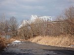
The Outerbridge Crossing, also known as the Outerbridge, is a cantilever bridge that spans the Arthur Kill between Perth Amboy, New Jersey, and Staten Island, New York. It carries New York State Route 440 and New Jersey Route 440, with the two roads connecting at the state border near the bridge's center. The Outerbridge Crossing is one of three vehicular bridges connecting New Jersey with Staten Island, and like the others, is maintained and operated by the Port Authority of New York and New Jersey. The others are the Bayonne Bridge (also carrying Route 440), which connects Staten Island with Bayonne, and the Goethals Bridge (carrying I-278, which connects the island with Elizabeth).
Excerpt from the Wikipedia article Outerbridge Crossing (License: CC BY-SA 3.0, Authors, Images).Outerbridge Crossing
Outerbridge Crossing,
Geographical coordinates (GPS) Address External links Nearby Places Show on map
Geographical coordinates (GPS)
| Latitude | Longitude |
|---|---|
| N 40.525 ° | E -74.247 ° |
Address
Outerbridge Crossing
Outerbridge Crossing
08861 , Staten Island
New Jersey, United States
Open on Google Maps


