Mission Hill, Boston
All pages needing cleanupHistoric districts in Suffolk County, MassachusettsHistoric districts on the National Register of Historic Places in MassachusettsNRHP infobox with nocatNational Register of Historic Places in Boston ... and 5 more
Neighborhoods in BostonRoxbury, BostonStreetcar suburbsUse mdy dates from December 2019Wikipedia introduction cleanup from March 2016

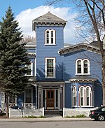
Mission Hill is a 3⁄4 square mile (2 square km), primarily residential neighborhood of Boston, bordered by Roxbury, Jamaica Plain and Fenway-Kenmore and the town of Brookline. It is home to several hospitals and universities, including Brigham and Women's Hospital and New England Baptist Hospital. Mission Hill is known for its brick row houses and triple decker homes of the late 19th century. The population was estimated at 15,883 in 2011.
Excerpt from the Wikipedia article Mission Hill, Boston (License: CC BY-SA 3.0, Authors, Images).Mission Hill, Boston
Huntington Avenue, Boston Mission Hill
Geographical coordinates (GPS) Address Nearby Places Show on map
Geographical coordinates (GPS)
| Latitude | Longitude |
|---|---|
| N 42.333422222222 ° | E -71.107677777778 ° |
Address
Huntington Avenue
02120 Boston, Mission Hill
Massachusetts, United States
Open on Google Maps


