Rizal Avenue
Santa Cruz, ManilaStreets in ManilaUse Philippine English from November 2022Use mdy dates from November 2022

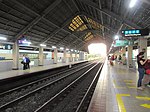
Rizal Avenue, also known as Avenida or Avenida Rizal, is one of Manila's main thoroughfares running from its Santa Cruz and Quiapo districts to the Bonifacio Monument (Monumento) Circle in Caloocan. Named after the national hero José Rizal, it is a part of Radial Road 9 (R-9). The LRT Line 1 elevated railroad is built above the street in its entire length, and several jeepneys ply the area taking passengers from Caloocan, Quezon City, and Valenzuela. Most of the street is within Santa Cruz, Manila. By the 1960s, economic activities shifted from Binondo to Makati. The avenue forms part of National Route 150 (N150) of the Philippine highway network.
Excerpt from the Wikipedia article Rizal Avenue (License: CC BY-SA 3.0, Authors, Images).Rizal Avenue
Rizal Avenue, Manila Santa Cruz (Third District)
Geographical coordinates (GPS) Address Nearby Places Show on map
Geographical coordinates (GPS)
| Latitude | Longitude |
|---|---|
| N 14.615555555556 ° | E 120.9825 ° |
Address
Department of Health San Lazaro Compound
Rizal Avenue
1942 Manila, Santa Cruz (Third District)
Philippines
Open on Google Maps


