place

Signal Hill (Canton, Massachusetts)
2005 establishments in MassachusettsHills of MassachusettsLandforms of Norfolk County, MassachusettsNorfolk County, Massachusetts geography stubsOpen space reserves of Massachusetts
Protected areas established in 2005Protected areas of Norfolk County, MassachusettsThe Trustees of Reservations
Signal Hill P1130632

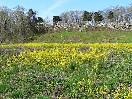
Signal Hill is a 150-acre (61 ha) open space preserve located in Canton, in the U.S. state of Massachusetts; it is centered on a 188-foot (57 m) rocky knoll by the same name. The property, acquired in 2005 by the land conservation non-profit organization The Trustees of Reservations, offers frontage on the Neponset River and views of Great Blue Hill and Downtown Boston from open ledges. The Signal Hill preserve also includes wetlands, open fields, and a car-top boating access point.Signal Hill contains the Wamsutta archaeological site, discovered during construction of Interstate 95, which was a seasonal camp for Paleo-Indians radiocarbon dated by nearby charcoal remains to 12,140 before present, around the time of the last glacial retreat, when rapid melting of the Wisconsin continental glacier created the mile-wide channel through which today's Neponset River flows. At this time, Signal Hill was a peninsula extending into a large lake of glacial meltwater.It is currently abutted by Interstate 95 as well as industrial and suburban land to the east, and river floodplain to the west. The preserve is open to non-motorized carry-in boating, hiking, picnicking, fishing, and similar pursuits. A trailhead for the 1.3 mile trail system is located on University Road in Canton.

Excerpt from the Wikipedia article Signal Hill (Canton, Massachusetts) (License: CC BY-SA 3.0, Authors, Images).

Signal Hill (Canton, Massachusetts)
University Road,

Geographical coordinates (GPS) Address Website External links Nearby Places
placeShow on map

Wikipedia: Signal Hill (Canton, Massachusetts)Continue reading on Wikipedia

Geographical coordinates (GPS)

Latitude Longitude
N 42.185 ° E -71.159 °
placeShow on map

Address

Signal Hill

University Road
02021
Massachusetts, United States
mapOpen on Google Maps

Website
thetrustees.org

linkVisit website

linkWikiData (Q7512662)
linkOpenStreetMap (64916)

Signal Hill P1130632
Share experience

Nearby Places

1956 PGA Championship

The 1956 PGA Championship was the 38th edition of the professional golf competition, held at Blue Hill Country Club in Canton, Massachusetts, a suburb southwest of Boston. Jack Burke Jr. won his second major championship of 1956, a 3 & 2 victory over Ted Kroll; Burke had won the Masters in April. It was the penultimate PGA Championship as a match play competition; stroke play was introduced two years later in 1958. This was the tenth and final year the PGA Championship was scheduled for a Tuesday finish. Defending champion Doug Ford was stopped in the third round by 1953 champion Walter Burkemo, 5 & 3.Blue Hill was not highly regarded as a championship venue and calls increased for a change in format to stroke play. Also, a five-year membership in the PGA of America was necessary to compete in the PGA Championship at the time; this excluded young professionals Arnold Palmer, Dow Finsterwald, Gene Littler, and Mike Souchak.This remains the only time the PGA Championship has been played in Massachusetts. It was the 8th major championship played in the state and the first in over 30 years, since the 1925 U.S. Open. The next major held in the state would be the 1963 U.S. Open. Burke was the second to win the Masters and PGA Championship in the same calendar year, following Sam Snead in 1949. Through 2016, it has only been accomplished four times, with the latter two by Jack Nicklaus in 1963 and 1975. The Open Championship was held two weeks earlier in England at Royal Liverpool Golf Club; neither Burke nor Kroll played in 1956 (or ever). In the skills competitions held on Thursday, Joe Kraak won the long driving contest at 300 yards (274 m).