Sans Souci, New South Wales
Bayside CouncilBotany BayGeorges River CouncilSuburbs of SydneyUse Australian English from August 2019

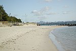
Sans Souci () is a Southern Sydney suburb in the state of New South Wales, Australia. Sans Souci is 17 kilometres south of the Sydney central business district and lies across the local government areas of the Bayside Council and the Georges River Council. It is part of the St George area. Sans Souci sits on the western shore of Botany Bay. Lady Robinsons Beach and Cook Park run along the eastern border. Kogarah Bay runs along the western border. Sans Souci is connected to Taren Point, in the Sutherland Shire, to the south, by the Captain Cook Bridge over the Georges River.
Excerpt from the Wikipedia article Sans Souci, New South Wales (License: CC BY-SA 3.0, Authors, Images).Sans Souci, New South Wales
Horbury Street, Sydney Sans Souci
Geographical coordinates (GPS) Address Nearby Places Show on map
Geographical coordinates (GPS)
| Latitude | Longitude |
|---|---|
| N -33.98898 ° | E 151.1393 ° |
Address
Horbury Street
Horbury Street
2219 Sydney, Sans Souci
New South Wales, Australia
Open on Google Maps


