Breakneck Ridge

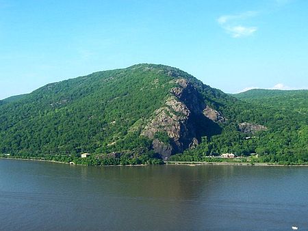
Breakneck Ridge is a mountain along the Hudson River between Beacon and Cold Spring, New York, straddling the boundary between Dutchess and Putnam counties. Its distinctive rocky cliffs are visible for a long distance when approached from the south, and together with Storm King Mountain on the opposite bank of the river forms Wey-Gat, or Wind Gate, the picturesque northern gateway to the Hudson Highlands. It has several summits, the highest, some distance inland, reaching approximately 1,260 feet (384 m) above sea level. The southern face of the peak is remarkable for its striking cliffs, the result of quarrying in past years. Lying within Hudson Highlands State Park, it offers many stunning views of the river and region and is quite popular with hikers, to the point that a rail flag stop has been established on the Metro North line which runs right by the base of the ridge along NY 9D. In 1932 a road tunnel was dug below the western slopes of the peak; it is now designated as part of Route 9D. Until the early 20th century, the mountain was also known as St. Anthony's Face or Turk's Face, after a facelike stone formation on the southern cliffs that was destroyed by quarrymen in 1846. (This references a different mountain, “Anthony’s Nose” not Breakneck. )
Excerpt from the Wikipedia article Breakneck Ridge (License: CC BY-SA 3.0, Authors, Images).Breakneck Ridge
Lake Surprise Road,
Geographical coordinates (GPS) Address Nearby Places Show on map
Geographical coordinates (GPS)
| Latitude | Longitude |
|---|---|
| N 41.459722222222 ° | E -73.958888888889 ° |
Address
Lake Surprise Road 382
10516
New York, United States
Open on Google Maps


