Sarah's Cottage, Isle of Man
All image captions for cleanupImage captions for cleanup/Without examplesImage captions for cleanup from December 2019Roads in the Isle of ManUse British English from December 2017

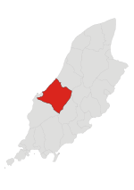
Sarah's Cottage (Manx: Ballavaish [baləˈveːʃ], 'farm of the steep sided hill') is situated between the 11th milestone and 12th milestones on Creg Willey’s Hill on the primary A3 Castletown to Ramsey Road in the parish of Kirk German in the Isle of Man.
Excerpt from the Wikipedia article Sarah's Cottage, Isle of Man (License: CC BY-SA 3.0, Authors, Images).Sarah's Cottage, Isle of Man
A3, German
Geographical coordinates (GPS) Address Nearby Places Show on map
 Continue reading on Wikipedia
 Geographical coordinates (GPS)
| Latitude | Longitude |
|---|---|
| N 54.227972222222 ° | E -4.6201111111111 ° |
Address
A3
German
Isle of Man
Open on Google Maps