Ballacraine
All image captions for cleanupImage captions for cleanup/Without examplesImage captions for cleanup from December 2019Roads in the Isle of ManUse British English from February 2017
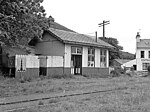
Ballacraine (Manx: [baləˈkʰɾɛːn], "McCrayne" or "Craine's farm"; archaic Ballagarraghan Beg) is located between the 7th and 8th milestones of the TT course, at the junction of the A1 Douglas to Peel and A3 Castletown to Ramsey primary roads in the parish of German in the Isle of Man. It is now at the east end of the ribbon development of St. John's village. At the junction is the former public house, the Ballacraine Inn, now a private residence.
Excerpt from the Wikipedia article Ballacraine (License: CC BY-SA 3.0, Authors).Ballacraine
Curragh Road, German
Geographical coordinates (GPS) Address Nearby Places Show on map
 Continue reading on Wikipedia
 Geographical coordinates (GPS)
| Latitude | Longitude |
|---|---|
| N 54.202722222222 ° | E -4.6290833333333 ° |
Address
Curragh Road
Curragh Road
German
Isle of Man
Open on Google Maps