place

Devil's Elbow, Isle of Man

Isle of Man geography stubsRoads in the Isle of ManUse British English from June 2015
The 'Devils elbow', Isle of Man geograph.org.uk 251413

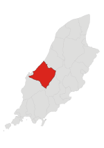
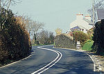
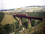
Devil's Elbow (Manx: Glion Cam or Glen Cam the Winding Glen) is a hairpin bend situated on the primary A4 Peel to Kirk Michael coast road in the Isle of Man parish of German.The A4 road follows the island's west coast and the Devil's Elbow hairpin intersects Glion Cam, a small wooded glen and former quarry situated between Lower Ballakaighen and Skerrisdale Moar. The former Peel to Ramsey line of the Manx Northern Railway also runs parallel to the coast road from Knocksharry to Glen Wyllin near Kirk Michael at this point. This includes the nearby Gob-y-Deigan or the Donkey Bank and a further railway embankment at Lady Port on the western-edge of Glen Cam which is 70 ft high formed of 50,000 cubic yards of excavated material from a nearby railway cutting.The Devil's Elbow was part of the Short Highland Course as part of the Peel Loop used for Tourist Trophy car races held between 1905 and 1907. It was part of the 15-mile 1,470 yard St. John's Short Course used for motorcycle racing in the Isle of Man TT races between 1907 and 1910, situated at the 9th milestone, 416 ft above sea level.

Excerpt from the Wikipedia article Devil's Elbow, Isle of Man (License: CC BY-SA 3.0, Authors, Images).

Devil's Elbow, Isle of Man
Coast Road, German

Geographical coordinates (GPS) Address External links Nearby Places
placeShow on map

Wikipedia: Devil's Elbow, Isle of ManContinue reading on Wikipedia

Geographical coordinates (GPS)

Latitude Longitude
N 54.255555555556 ° E -4.6255555555556 °
placeShow on map

Address

Coast Road (Ramsey Road)

Coast Road
German
Isle of Man
mapOpen on Google Maps

linkWikiData (Q108802802)
linkOpenStreetMap (40998725)

The 'Devils elbow', Isle of Man geograph.org.uk 251413
Share experience

Nearby Places

Handley's Corner, Isle of Man

Handley's Corner (formerly Ballamenagh Corner) is situated just before the 12th Milestone road-side marker, measured from the startline at the TT Grandstand, on the Snaefell Mountain Course used for the Isle of Man TT races on the primary A3 road, in the parish of Michael, in the Isle of Man. The previous course landmark is the 11th Milestone and the next is McGuinness's, named in 2013 after TT rider John McGuinness, just preceding the next point at Barregarrow. The S-bend at Ballamenagh Corner, dominated by a high stone wall on the eastern side, was part of the Highland Course and the Four Inch Course used for the Gordon Bennett Trial and Tourist Trophy car races held between 1904 and 1922. The Ballamenagh Corner was part of the St John's Short Course used between 1907 and 1910 for the TT races. Later named Handley's Corner, it became part of the Snaefell Mountain Course used since 1911 for the TT and from 1923 for the Manx Grand Prix races. The area is dominated by the Ballamenagh and Shoughlaige-e-Caine farmland. The name derives from the TT race winner Wal Handley who, while riding a Rudge motorcycle, crashed heavily during lap 4 of the 1932 Senior TT race, sustained a back injury and subsequently retired from the race. The corner underwent road widening and reprofiling during the winter of 1953/1954 for the 1954 TT races. From the winter of 2003 to 2006, road repair work was carried-out on the primary A3 road from Barregarrow to Cronk-y-Voddy, including Handley's Corner and the 11th Milestone, by the Department of Transport.