Gob-y-Deigan railway station
Isle of Man stubsRailway stations closed in 1887Railway stations in the Isle of ManRailway stations opened in 1887Use British English from March 2017

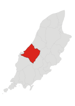
Gob-Y-Deigan Railway Station (Manx: Stashoon Raad Yiarn Ghob-Y-Deigan) was a station on the Manx Northern Railway, later owned and operated by the Isle of Man Railway; it served a beach near Kirk Michael in the Isle of Man and was an intermediate stopping place on a line that ran between St. John's and Ramsey.
Excerpt from the Wikipedia article Gob-y-Deigan railway station (License: CC BY-SA 3.0, Authors, Images).Gob-y-Deigan railway station
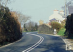
Coast Road, German
Geographical coordinates (GPS) Address Nearby Places Show on map
 Continue reading on Wikipedia
 Geographical coordinates (GPS)
| Latitude | Longitude |
|---|---|
| N 54.253 ° | E -4.633 ° |
Address
Coast Road (Ramsey Road)
Coast Road
German
Isle of Man
Open on Google Maps