place

Santa Susana Pass State Historic Park

California State Historic ParksChatsworth, Los AngelesGeography of Los Angeles County, CaliforniaHistory of Los AngelesHistory of Los Angeles County, California
History of Ventura County, CaliforniaHistory of the San Fernando ValleyLandmarks in CaliforniaLos Angeles Historic-Cultural MonumentsParks in Los AngelesParks in Los Angeles County, CaliforniaParks in the San Fernando ValleyProtected areas established in 1998Regional parks in CaliforniaSan Fernando ValleySanta Susana MountainsSimi Hills
Santa Susana State Historic Park Map

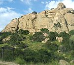
Santa Susana Pass State Historic Park is a California State Park of 670.68 acres (2.7141 km2) located in the city of Los Angeles, in Los Angeles County on the boundary between Ventura and Los Angeles counties, between the communities of Chatsworth and Simi Valley. Geologically, the park is located where the Simi Hills meet the Santa Susana Mountains. Here in the western part of the Transverse Ranges, the land is dominated by high, narrow ridges and deep canyons covered with an abundant variety of plant life. The park offers panoramic views of the rugged natural landscape as a striking contrast to the developed communities nearby. The park is also rich in archaeological, historical, and cultural significance.

Excerpt from the Wikipedia article Santa Susana Pass State Historic Park (License: CC BY-SA 3.0, Authors, Images).

Santa Susana Pass State Historic Park
Bannon Quarry Trail, Los Angeles

Geographical coordinates (GPS) Address Nearby Places
placeShow on map

Wikipedia: Santa Susana Pass State Historic ParkContinue reading on Wikipedia

Geographical coordinates (GPS)

Latitude Longitude
N 34.256666666667 ° E -118.62055555556 °
placeShow on map

Address

Bannon Quarry Trail

Bannon Quarry Trail
91311 Los Angeles
California, United States
mapOpen on Google Maps

Santa Susana State Historic Park Map
Share experience

Nearby Places

Chatsworth station
Chatsworth station

Chatsworth station (also known as Chatsworth Transportation Center) is an intermodal passenger transport station in the Los Angeles neighborhood of Chatsworth, United States. It is served by Amtrak inter-city rail service, Metrolink commuter rail service, Los Angeles Metro Busway bus rapid transit, and several transit bus operators. Chatsworth station is served by ten Amtrak Pacific Surfliner trains (five in each direction) every day, with departures evenly spaced throughout the day. Sixteen Metrolink Ventura County Line trains (eight in each direction) serve the station each weekday, running during peak hours in the peak direction of travel. On weekends, four Metrolink Ventura County Line trains (two in each direction) serve the station. Metrolink passengers also have access to all Pacific Surfliner trains through a codesharing arrangement with Amtrak.It is also the northern terminus of the Metro G Line. The station is also served by Los Angeles Metro Bus and Simi Valley Transit local buses, plus Santa Clarita Transit and LADOT Commuter Express regional express bus routes. The Southern Pacific Railroad (SP) opened its first Chatsworth station in 1893; SP service ended in the 1950s. CalTrain service from 1982 to 1983, and Amtrak service beginning in 1988, used a station located 1.2 miles (1.9 km) to the southeast. Metrolink service began in 1992 with a station near the former SP station site; Amtrak service soon moved there. A station building was completed in 1996, and bus rapid transit service began in 2012.

Browns Creek Bike Path

Browns Creek Bike Path is a Class I bike path that is “tucked away from the surrounding hustle and bustle” of the San Fernando Valley, “hugging the side” of the Browns Canyon Wash. The path begins at Lassen Street, just east of Chatsworth Metrolink Station, and ends just north of Rinaldi Street near Stoney Point Park. Browns Creek (sometimes called Brown’s Creek), a tributary of the Los Angeles River, offers “splendid views of the irregularly shaped Santa Susana mountains rising to the west.” One local writer observed, “What [the concrete-lined creek] lacks in scenery, it compensates for by providing the trail with an open, airy setting.” The route has been described as “very rustic” (for an urban bike path, of course). The wash passes through a neighborhood with equestrian zoning and “Opposite the bike route, in the west levee, a horse trail also follows the creek.” Domestic goats, roosters and ponies have also been seen along the path. At Chatsworth station, bicyclists can connect to the G Line Bikeway. The path is in close proximity to Chatsworth Park North and Chatsworth Park South (both operated by the City of Los Angeles Parks Department) and Chatsworth Nature Preserve. Both Chatsworth Parks, “excellent parks…[with] interesting hills and rock formations there, as well as pleasant shaded rest areas” are accessible from Valley Circle Road. Riders can create an approximately 6.3-mile (10.1 km) loop beginning at either end of the Browns Creek route, connecting to Valley Circle Road via either Chatsworth Street or Lassen Street.

2008 Chatsworth train collision

The 2008 Chatsworth train collision occurred at 4:22:23 p.m. PDT (23:22:23 UTC) on September 12, 2008, when a Union Pacific Railroad freight train and a Metrolink commuter rail train collided head-on in the Chatsworth neighborhood of Los Angeles, California, United States. The scene of the accident was a curved section of single track on the Metrolink Ventura County Line just east of Stoney Point. According to the National Transportation Safety Board (NTSB), which investigated the cause of the collision, the Metrolink train ran through a red signal before entering a section of single track where the opposing freight train had been given the right of way by the train dispatcher. The NTSB blamed the Metrolink train's engineer, 46-year-old Robert M. Sanchez, for the collision, concluding that he was distracted by text messages he was sending while on duty. This mass casualty event brought a massive emergency response by both the city and county of Los Angeles, but the nature and extent of physical trauma taxed the available resources. First responding officer Tom Gustofson described the wreck as “beyond human description”. Response included California Emergency Mobile Patrol Search and Rescue (CEMP) as a first responding unit requested by Los Angeles Police Department (LAPD). With 25 deaths, this was the deadliest accident in Metrolink's history. Many survivors remained hospitalized for an extended period. Lawyers quickly began filing claims against Metrolink. The accident launched and reinvigorated public debate on a range of topics including public relations, emergency management, and safety, which has driven various regulatory and legislative actions, including the Rail Safety Improvement Act of 2008.