place

Kinross, Western Australia

Suburbs in the City of JoondalupSuburbs of Perth, Western AustraliaUse Australian English from March 2014Vague or ambiguous time from October 2021
Kinross CallanderPark IndianOcean

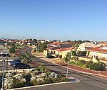
Kinross is a small suburb in the City of Joondalup located in the northern suburbs of Perth in Western Australia. Kinross was constructed around 1992-3 in various stages. It is bordered by Neerabup National Park to the northeast, Tamala Park to the north, Burns Beach to the west and Currambine to the south. It is the City of Joondalup's northernmost suburb. Kinross mostly contains young families and overseas migrants, especially from the United Kingdom, Ireland and South Africa. Several parks are dotted through the suburb, most of which offer playground facilities. The Scottish influence in Kinross extends throughout the suburb with road names, parks and others mainly derived from Scottish place names, for example Glencoe Loop, Edinburgh Avenue, Roxburgh Circle, Selkirk Drive, Falkirk Court, Ben Nevis Turn, and Coatbridge Circuit.

Excerpt from the Wikipedia article Kinross, Western Australia (License: CC BY-SA 3.0, Authors, Images).

Kinross, Western Australia
Kinross Drive, Joondalup Kinross

Geographical coordinates (GPS) Address Nearby Places
placeShow on map

Wikipedia: Kinross, Western AustraliaContinue reading on Wikipedia

Geographical coordinates (GPS)

Latitude Longitude
N -31.722 ° E 115.74 °
placeShow on map

Address

Kinross Drive

Kinross Drive
6028 Joondalup, Kinross
Western Australia, Australia
mapOpen on Google Maps

Kinross CallanderPark IndianOcean
Share experience

Nearby Places

Ocean Reef, Western Australia

Ocean Reef is a suburb in northern Perth, Western Australia. It is located within the City of Joondalup. The name was coined by developers in the 1970s from the line of a reef visible several kilometres offshore. The name was formally adopted in 1974, replacing the prior name of Beaumaris, a name still retained by one of the shopping centres and one primary school. The suburb is divided in two by Hodges Drive, with the development to the south often referred to as 'old' Ocean Reef (there are only a few years between the two). The boat harbour sits on this midway point at the western end of Hodges Drive, and there is a shopping centre in each end of the suburb - Beaumaris Shopping Centre in the north and Ocean Reef Shopping Centre to the south. Roadworks have recently been completed to extend the foreshore road from Hodges Drive (south) to Shenton Ave (north), extending the 'Sunset Coast' drive into the adjacent suburb of Iluka. Located some 8 km north of the popular Hillarys Boat Harbour, the Ocean Reef Boat Harbour provides a public launching ramp for boats and a small fishing harbour. During recent years the City of Joondalup has prepared concept plans for the development of a world class recreational, residential, boating and tourism marina at the Ocean Reef Boat Harbour site (Ocean Reef Marina). The proposed development encapsulates high levels of environmental sustainability and community amenity. In 2009 the City of Joondalup asked the people of Ocean Reef and the surrounding suburbs what they thought of the proposed development. Out of a total of 11,728 survey respondents, an overwhelming majority - 93.9% - were in favour of developing the site and 95.6% approved of the concept plan. The Council has endorsed proceeding with the preparation of the necessary Business Case and Structure Plan for government approval. Ocean Reef is served by three primary schools (Beaumaris Primary, St Simon Peter Catholic Primary, and Ocean Reef Primary). A dune walkway and cycle path hugs the coast from south to north, offering access to several small beaches, picnic areas, rest stops, and access paths into the suburb itself. A large protected dune area which is at times around 400 metres wide separates the houses from the Indian Ocean.

Clarkson railway station, Perth

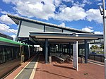
Clarkson railway station (officially Clarkson Station) is a commuter rail station in Clarkson, a suburb of Perth, Western Australia. It is on the Joondalup line, which is part of the Transperth network. Located in the median of the Mitchell Freeway, the station consists of an island platform connected to the west by a pedestrian footbridge. A six stand bus interchange and two carparks are located near the entrance. Planning for an extension of the Joondalup line north of Currambine railway station was underway by 1995. The government committed to an extension to Clarkson the following year, and a plan detailing the extension was released in 2000. The first contract for the project, a $14 million earthworks contract, was awarded to Brierty Contractors in March 2001. In April 2002, Barclay Mowlem and Alstom were awarded a contract worth $17 million to design and build the extension's rail infrastructure, and in November 2002, a $8.7million contract was awarded to Transfield for the construction of the station. The station opened on 4 October 2004, with five new Transperth B-series trains entering service that day. The following day, bus services in the area were realigned to feed into Clarkson station. On 3 September 2013, there was a minor train crash at Clarkson station. On 21 September 2014, an extension of the Joondalup line 7.5 kilometres (4.7 mi) north to Butler railway station was opened. Clarkson station is 33.2 kilometres (20.6 mi) from Perth railway station, with train journeys there taking 32 minutes. Train headways reach as low as five minutes during peak hour, with off peak services at 15 minute headways. There are six bus routes that serve Clarkson station.