Currambine railway station

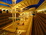
Currambine railway station (officially Currambine Station) is a commuter rail station on the border of Currambine and Joondalup, north of Perth, Western Australia. It is on the Joondalup line, which is part of the Transperth network. Located in the median of the Mitchell Freeway, the station consists of an island platform connected to the east and west by an underpass. Constructed by Doubikin Constructions Pty Ltd at a cost of $2.8 million, Currambine station opened on 8 August 1993 as the final station from the original plan for the Joondalup line. The station was originally built on the western side of the Mitchell Freeway reserve to limit the distance between the car park and platform. It was decided to relocate the station 60 m (200 ft) to the east during the extension of the Joondalup line to Clarkson, so that the station would be in the median of the Mitchell Freeway. This was done to reduce the noise and vibration impact on houses near the railway line and for consistency with the rest of the Joondalup line and Mandurah line. Constructed by John Holland at a cost of $3.2 million, the relocated station opened on 4 October 2004. Currambine station is 29.2 km (18.1 mi) from Perth station, with train journeys there taking 29 minutes. Train headways reach as low as five minutes during peak hour, with off peak services at 15 minute headways.
Excerpt from the Wikipedia article Currambine railway station (License: CC BY-SA 3.0, Authors, Images).Currambine railway station
Mitchell Freeway, Joondalup
Geographical coordinates (GPS) Address External links Nearby Places Show on map
Geographical coordinates (GPS)
| Latitude | Longitude |
|---|---|
| N -31.725 ° | E 115.75055555556 ° |
Address
Currambine
Mitchell Freeway
6028 Joondalup (Joondalup)
Western Australia, Australia
Open on Google Maps


