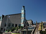
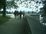
Saint-Charles River (Quebec City)
Landforms of Quebec CityRivers of Capitale-NationaleTributaries of the Saint Lawrence River

The Saint-Charles River (Huron-Wendat name is Akiawenrahk) is the main watercourse crossing Quebec City, Quebec, Canada. The surface of the Saint-Charles River (except the rapids areas) is generally frozen from the beginning of December to the end of March; however, safe circulation on the ice is generally done from the end of December to the beginning of March. The water level of the river varies with the seasons and the precipitation; the spring flood occurs in March or April.
Excerpt from the Wikipedia article Saint-Charles River (Quebec City) (License: CC BY-SA 3.0, Authors, Images).Saint-Charles River (Quebec City)
Montée des Cinquante, Quebec Maizerets (La Cité-Limoilou)
Geographical coordinates (GPS) Address Nearby Places Show on map
 Continue reading on Wikipedia
 Geographical coordinates (GPS)
| Latitude | Longitude |
|---|---|
| N 46.826988 ° | E -71.197672 ° |
Address
Montée des Cinquante
Montée des Cinquante
G1K 8M8 Quebec, Maizerets (La Cité-Limoilou)
Quebec, Canada
Open on Google Maps