Habitation de Québec
Buildings and structures in Quebec CityHistory of Quebec City

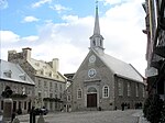
Habitation de Québec was an ensemble of buildings interconnected by Samuel de Champlain when he founded Québec during 1608. The site is located in what is now Vieux-Québec. It was located near the site of the abandoned First Nations village of Stadacona that Jacques Cartier had visited during 1535. It served as a fort and as dwellings for the new colony in New France.
Excerpt from the Wikipedia article Habitation de Québec (License: CC BY-SA 3.0, Authors, Images).Habitation de Québec
Rue Saint-Pierre, Quebec
Geographical coordinates (GPS) Address Nearby Places Show on map
 Continue reading on Wikipedia
 Geographical coordinates (GPS)
| Latitude | Longitude |
|---|---|
| N 46.8129 ° | E -71.2025 ° |
Address
Rue Saint-Pierre 29
G1K 4G6 Quebec (La Cité-Limoilou)
Quebec, Canada
Open on Google Maps