Barre Falls Dam
Buildings and structures in Barre, MassachusettsDams completed in 1959Dams in MassachusettsUnited States Army Corps of Engineers dams

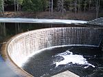
The Barre Falls Dam is located on the Ware River in Barre, Massachusetts, about 0.3 miles (0.48 km) below the junction of the river's east and west branches and 13 miles (21 km) northwest of Worcester, Massachusetts. Designed and constructed by the United States Army Corps of Engineers, this dam substantially reduces flooding along the Ware, Chicopee, and Connecticut rivers. Construction of the project began in May 1956 with completion in July 1958 at a cost of US$2 million. The Barre Falls reservoir is located within the Upper Ware River Watershed and is part of the Chicopee River Watershed. Access to the site is available from Route 62.
Excerpt from the Wikipedia article Barre Falls Dam (License: CC BY-SA 3.0, Authors, Images).Barre Falls Dam
Geographical coordinates (GPS) Address Nearby Places Show on map
Geographical coordinates (GPS)
| Latitude | Longitude |
|---|---|
| N 42.427777777778 ° | E -72.025277777778 ° |
Address
Ware River Watershed
01452
Massachusetts, United States
Open on Google Maps


