place

Penygroes, Gwynedd

Dyffryn NantlleLlanllyfniVillages in Gwynedd
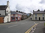
Penygroes War Memorial geograph.org.uk 141335

Penygroes (Welsh pronunciation: [ˌpɛnəˈɡroːɨs] (listen)) is a village in Gwynedd, Wales. The village is located to the south of Caernarfon, and north of Porthmadog, by the A487 road. Penygroes' population stands at 1,793 at the 2011 census, of which 88% are Welsh-speaking, making it one of the most predominantly Welsh-speaking areas of the country. The population of Llanllyfni community, which includes Penygroes and Llanllyfni village, which practically adjoins Penygroes, plus Talysarn, is 4,135 according to the 2011 census.

Excerpt from the Wikipedia article Penygroes, Gwynedd (License: CC BY-SA 3.0, Authors, Images).

Penygroes, Gwynedd
Victoria Road,

Geographical coordinates (GPS) Address Nearby Places
placeShow on map

Wikipedia: Penygroes, GwyneddContinue reading on Wikipedia

Geographical coordinates (GPS)

Latitude Longitude
N 53.053 ° E -4.283 °
placeShow on map

Address

Heol Buddug / Victoria Road

Victoria Road
LL54 6HD , Llanllyfni
Wales, United Kingdom
mapOpen on Google Maps

Penygroes War Memorial geograph.org.uk 141335
Share experience

Nearby Places

Penygroes railway station

Penygroes railway station was located in Penygroes, Gwynedd, Wales.The narrow gauge, horse-drawn Nantlle Railway had a station near the site from 1856. From the outset timetables appeared regularly in the "Carnarvon & Denbigh Herald" and in Bradshaw from October 1856. In 1865 the narrow gauge line was closed, to be replaced and updated to standard gauge with contemporary facilities. It reopened in its eventual form in 1867 and closed in December 1964. The station served as the junction station for the short branch to Nantlle which was overlain in 1872 on part of the former Nantlle Railway route, but its main purpose was for traffic on the former Carnarvonshire Railway line from Caernarvon to Afon Wen and beyond.When the line and station were first opened in 1867 a locomotive was hired from the Cambrian Railways. A Cambrian driver, who had never been over the line before, was retained to drive the first directors' inspection special from Afon Wen to Carnarvon (Pant). On the return journey the loco ran short of coal and ran out of steam at Penygroes. There was some peat in a nearby field, which the crew dug and the directors carried to the engine enabling steam to be raised.The passenger service along the Nantlle Branch was withdrawn in 1932, though excursions continued until 1939. The station and line closed on 7 December 1964 as recommended in the Beeching Report. The station building and footbridge remained in place, but increasingly derelict, until at least 1970.

Groeslon
Groeslon

Groeslon (Welsh pronunciation; Welsh: Y Groeslon, "the crossroads") is a small village in the community of Llandwrog in the Welsh traditional county of Caernarfonshire. Groeslon is administered by Gwynedd Council. The population was 880 at the 2011 censusNearby villages are Penygroes, Carmel and Dinas. The village lies approximately five miles south of Caernarfon. It has one primary school in the centre of the village and no secondary schools. Most secondary school age pupils go to Ysgol Dyffryn Nantlle in Penygroes. Groeslon was by-passed in 2002 by the A487 road, a trunk road which cost around £12 million to complete. A bat bridge was constructed in 2010 to guide lesser horseshoe bats across the road. Formerly an agricultural and slate mining village, Groeslon is now expanding as a commuter village for the surrounding towns, especially Caernarfon and Bangor. Its initial growth came as a result of the construction of the LMS railway in 1867. Groeslon railway station closed in December 1964. The railway line is now part of the national cycle route. In the village there is one pub called the Penionyn. At the bottom of the village, bordering the A487, a huge wall becomes visible. This is the wall to the Glynllifon estate, formerly the seat of Lord Newborough, which is now a country park and college (Meirion Dwyfor) specialising in land based industries, e.g. agriculture, equine studies and arboriculture. Groeslon is covered by a Neighbourhood Policing Team based in Penygroes.

Nantlle railway station

Nantlle was a railway station located in Talysarn, a neighbouring village to Nantlle, in Gwynedd, Wales. From 1828 the narrow gauge, horse-drawn Nantlle Railway ran from wharves at Caernarfon through Penygroes and through the site of the future Nantlle station to slate quarries around the village of Nantlle. In the 1860s the Carnarvonshire Railway built a new standard gauge line southwards from Caernarfon to Afon Wen, replacing the Nantlle Railway's tracks as far south as Penygroes. The Nantlle quarries and railway were very much still in business, so they continued to send their products to Caernarfon by transhipping them onto the new railway at Tyddyn Bengam a short distance north of Penygroes. This arrangement continued until 1872 when the LNWR repeated the earlier process and built a standard gauge branch partly on the Nantlle Railway trackbed from Penygroes to Talysarn, where it built a wholly new passenger station which it called Nantlle, though in reality the branch only reached half way to the village of Nantlle. This station included a locomotive servicing area at its eastern end.From then onwards products were transshipped from the quarry wagons onto standard gauge wagons in the goods yard at "Nantlle" station. The narrow gauge wagons were manoeuvred by horse and by hand, a way of working which, remarkably, survived until 1963. Passenger traffic along the branch, which was less than a mile and a half long, was not heavy. The station closed to normal passenger traffic in 1932, though excursion traffic (mostly outbound from Nantlle) continued until 1939. The station closed completely in 1963. The station building was still standing in 2012, though most other infrastructure had long been built over.

Nantlle Valley
Nantlle Valley

The Nantlle Valley (Welsh: Dyffryn Nantlle, IPA: [ˈdəfrɨn ˈnantɬɛ]) is an area in Gwynedd, North Wales, characterised by its numerous small settlements. The area is also historically important geologically, and featured in one of the most contentious disputes of the 19th century, between the 'Diluvialists' who believed in the Biblical flood, and the ‘Glacialists’, who supported the Glacial Theory, which was substantially established by studies of the drift sediments on Moel Tryfan.Between 85 and 90% of the population of the Nantlle Valley speak Welsh as their first language.Some of the communities came into being as a result of slate quarrying in the late eighteenth or early nineteenth centuries, and some have a history stretching back to antiquity. There are Iron Age forts at Caer Engan in Pen-y-groes and on the coast at Dinas Dinlle and evidence of Bronze Age settlement on the higher ground. The valley was important during the Middle Ages, with a clas or ecclesiastical college developed at Clynnog Fawr.The Glynllifon estate can trace its foundation historically to the 8th century and there is evidence of occupation on the site going back to the Iron Age.There were a number of quarries in the valley, the largest being the Dorothea and Pen yr Orsedd quarries. Although the major quarries are worked out, there remains demand for slate waste for garden decoration.In 1991, Antur Nantlle Cyf was established as a community enterprise to work for the benefit of the Nantlle Valley and its surrounding area.