place

Subang Jaya station

Port Klang LineRailway stations in SelangorRapid transit stations in Selangor
Subang Jaya station outview (220108)

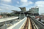
The Subang Jaya station is a railway station located in SS16, Subang Jaya. It is served by the KTM Komuter Port Klang Line and Skypark Link, as well as the LRT Kelana Jaya Line. The station is situated at the city centre of Subang Jaya behind Subang Parade and AEON Big Subang. It is a popular train and bus hub and is commonly used by college students for travel to and from colleges and universities like SEGi University, Taylor's University, Monash University, INTI College, the University of Wollongong and Sunway University. The journey time to KL Sentral from this station is approximately 30 minutes. Buses that offer services from the station include Bas Selangorku and Rapid KL.

Excerpt from the Wikipedia article Subang Jaya station (License: CC BY-SA 3.0, Authors, Images).

Subang Jaya station
LRT Linked Bridge, Subang Jaya

Geographical coordinates (GPS) Address External links Nearby Places
placeShow on map

Wikipedia: Subang Jaya stationContinue reading on Wikipedia

Geographical coordinates (GPS)

Latitude Longitude
N 3.0847222222222 ° E 101.58805555556 °
placeShow on map

Address

KD09 Subang Jaya (KTM Subang Jaya)

LRT Linked Bridge
47500 Subang Jaya
Selangor, Malaysia
mapOpen on Google Maps

linkWikiData (Q7630760)
linkOpenStreetMap (257615491)

Subang Jaya station outview (220108)
Share experience

Nearby Places

Petaling District
Petaling District

The Petaling District is a district located in the heart of Selangor in Malaysia, not to be confused with the city of Petaling Jaya located in it, nor the mukim of Petaling within Petaling Jaya City Council within Petaling district. The district office is located in Subang. The district of Petaling was established on 1 February 1974, the same day Kuala Lumpur was declared a Federal Territory. This district is located in the middle of the Klang Valley adjacent o the capital and thus has experienced tremendous urbanisation. Some of the original forests remain in the Bukit Cherakah Forest Reserve (including the National Botanic Gardens), Kota Damansara Community Forest Park and Bukit Gasing. During the 1991 census, it recorded 633,165 people.In the official 2010 census, it recorded 1,660,869 people. (exclude foreign) It covers some 484.32 km² in area. The urban centres are divided into the cities of Shah Alam, Petaling Jaya and Subang Jaya . However, there are numerous town subdivisions, old subdistrict administrations (mukim), all of which share the same names like Damansara, Subang, and Petaling, which add much to the administrative confusion along with the rapid growth. Some five types of subdivisions exist for Petaling District, namely the re-organized municipal council majlis, the majlis subdivisions, the community names (also known as townships), electoral constituencies, and the subdivisions ("mukim"). It is host to many thriving townships such as the Damansara area, which hosts several shopping malls including a Tesco and an IKEA outlet. Sultan Abdul Aziz Shah Airport is situated in Subang.