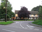
Lower Woodside
Bedfordshire geography stubsCentral Bedfordshire DistrictHamlets in Bedfordshire

Lower Woodside is a hamlet in the Central Bedfordshire district of Bedfordshire, England. The settlement lies north of Aley Green and south-west of Woodside. Lower Woodside forms part of the wider Slip End civil parish, and is close to the county border with Hertfordshire. The nearest large town to the settlement is Luton.
Excerpt from the Wikipedia article Lower Woodside (License: CC BY-SA 3.0, Authors, Images).Lower Woodside
Manor Road,
Geographical coordinates (GPS) Address Nearby Places Show on map
Geographical coordinates (GPS)
| Latitude | Longitude |
|---|---|
| N 51.855 ° | E -0.4467 ° |
Address
Manor Road
Manor Road
LU1 4HJ
England, United Kingdom
Open on Google Maps


