place

Barton House, Bristol

Brutalist architecture in the United KingdomBuildings and structures in BristolResidential buildings completed in 1958Residential skyscrapers in England
Barton House Facing North 1

Barton House is a residential tower block in the Barton Hill area of Bristol, England. It is the city's oldest tower block and was officially opened on 23 July 1958.

Excerpt from the Wikipedia article Barton House, Bristol (License: CC BY-SA 3.0, Authors, Images).

Barton House, Bristol
Cotton Mill Lane, Bristol Redfield

Geographical coordinates (GPS) Address Nearby Places
placeShow on map

Wikipedia: Barton House, BristolContinue reading on Wikipedia

Geographical coordinates (GPS)

Latitude Longitude
N 51.4539 ° E -2.5608 °
placeShow on map

Address

Cotton Mill Lane
BS5 9TZ Bristol, Redfield
England, United Kingdom
mapOpen on Google Maps

Barton House Facing North 1
Share experience

Nearby Places

Lawrence Hill railway station

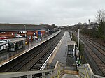
Lawrence Hill railway station is on the Severn Beach Line and Cross Country Route, serving the inner-city districts of Easton and Lawrence Hill in Bristol, England. It is 1.0 mile (1.6 km) from Bristol Temple Meads. Its three letter station code is LWH. The station has two platforms, four running lines and minimal facilities. It is managed by Great Western Railway, the seventh company to be responsible for the station and the third franchise since privatisation in 1997. They provide all train services at the station, the standard service being two trains per hour along the Severn Beach Line and an hourly service between Bristol Temple Meads and Filton Abbey Wood. The station was opened in 1863 by the Bristol and South Wales Union Railway, with a single track and platform. The line was doubled in 1874 when the Clifton Extension Railway opened, then expanded to four tracks and platforms in 1891. There were buildings on all platforms and a goods yard to the west. Service levels reduced significantly over the second half of the twentieth century. The goods facilities were closed in 1965, staff were withdrawn in 1967 and the eastern two platforms were taken out of service by 1974. The line is due to be electrified as part of the 21st-century modernisation of the Great Western Main Line, which will also see the addition of two new running lines to increase capacity. Service frequency will be improved as part of the Greater Bristol Metro scheme.

Netham Lock
Netham Lock

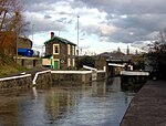
Netham Lock (grid reference ST616727) is the point at Netham in Bristol at which boats from the River Avon, acting as part of the Kennet and Avon Canal, gain access to Bristol's Floating Harbour. Construction started in 1804 to build the tidal New Cut and divert the River Avon along the Feeder Canal to the harbour; a system designed and built by William Jessop and later improved by Isambard Kingdom Brunel.A weir carries the river into the New Cut and boats use the adjacent lock. High tides often pass over the weir, and the river is effectively tidal to the next lock upstream at Hanham. Some spring tides can also pass over the weir at Hanham, making the river tidal as far as Keynsham Lock.Access to the harbour is only possible during the day when the lock keeper will open the gates unless the water level in the river between Netham and Hanham is above or below the level of the harbour.The maximum dimensions of a vessel which can pass through Netham Lock are: Length: 24.4 metres (80 ft) Beam: 5.4 metres (18 ft) Draught: 1.9 metres (6.2 ft) Headroom: 3.1 metres (10 ft)The lock-keeper's cottage, built in the early nineteenth century, is a grade II listed building and has a plaque listing it as Bristol Docks building number 1. The floral displays around the cottage and on the banking have attracted praise.Netham Lock and the weir form part of Bristol's flood defence mechanisms and it was announced in December 2008 that they would be upgraded as part of the £11 million City Docks Capital Project.