place

North Burnaby

Neighbourhoods in Burnaby
Hastings @ Ingleton
Hastings @ Ingleton

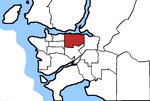
North Burnaby is a general name for a large neighbourhood in the City of Burnaby, British Columbia, that includes a number of smaller ones. It stretches from Boundary Road in the west to Burnaby Mountain with Simon Fraser University in the east and bounded by Burrard Inlet to the north and the Lougheed Highway to the south. It is a desirable place to live for many local and immigrant families which is reflected by real-estate prices that keep climbing and have doubled in the last 15 years.

Excerpt from the Wikipedia article North Burnaby (License: CC BY-SA 3.0, Authors, Images).

North Burnaby
Buchanan Street, Burnaby

Geographical coordinates (GPS) Address Nearby Places
placeShow on map

Wikipedia: North BurnabyContinue reading on Wikipedia

Geographical coordinates (GPS)

Latitude Longitude
N 49.266666666667 ° E -122.98333333333 °
placeShow on map

Address

Buchanan Street

Buchanan Street
V5B 2X7 Burnaby
British Columbia, Canada
mapOpen on Google Maps

Hastings @ Ingleton
Hastings @ Ingleton
Share experience

Nearby Places

Burnaby
Burnaby

Burnaby is a city in the Lower Mainland region of British Columbia, Canada. Located in the centre of the Burrard Peninsula, it neighbours the City of Vancouver to the west, the District of North Vancouver across the confluence of the Burrard Inlet with its Indian Arm to the north, Port Moody and Coquitlam to the east, New Westminster and Surrey across the Fraser River to the southeast, and Richmond on the Lulu Island to the southwest. Burnaby was incorporated in 1892 and achieved its city status in 1992. A member municipality of Metro Vancouver, it is British Columbia's third-largest city by population (after Vancouver and Surrey), and is the seat of Metro Vancouver's regional district government. 25% of Burnaby's land is designated as parks and open spaces, one of the highest in North America.The main campuses of Simon Fraser University and the British Columbia Institute of Technology are located in Burnaby. It is home to high-tech companies such as Ballard Power (fuel cell), Clio (legal software), D-Wave (quantum computing), General Fusion (fusion power), and EA Vancouver. Burnaby's Metropolis at Metrotown is the largest mall in British Columbia, the third most visited in Canada and the fifth largest in the nation. Canada's largest film and television production studio and more than 60% of BC's sound stages are in Burnaby, contributing to the growth of Hollywood North.The city is served by SkyTrain's Expo Line and Millennium Line. Metrotown station in downtown Metrotown is the busiest station on weekends and the second-busiest on weekdays in regional Vancouver's urban transit system as of 2021.

Greater Vancouver
Greater Vancouver

Greater Vancouver, also known as Metro Vancouver, is the metropolitan area with its major urban centre being the city of Vancouver, British Columbia, Canada. The term "Greater Vancouver" is roughly coterminous with the geographic area governed by the Metro Vancouver Regional District, though it predates the 1966 creation of the regional district. It is often used to include areas beyond the boundaries of the regional district but does not generally include wilderness and agricultural areas within that regional district. Usage of the term "Greater Vancouver" is not consistent. In local use it tends to refer to urban and suburban areas only, and does not include parts of the regional district such as Bowen Island, although industries such as the film industry even include Squamish, Whistler and Hope as being in "the Vancouver area" or "in Greater Vancouver". The business community often includes adjoining towns and cities such as Mission, Chilliwack, Abbotsford and Squamish within their use of the term "Greater Vancouver", though since the creation of the term "Metro Vancouver", that has come to be used in the media interchangeably with the name of the region and/or regional district. As a geographic region, Greater Vancouver is part of the Lower Mainland, one of British Columbia's three main geospatial/cultural divisions, and overlaps with the Lower Fraser Valley, with the Central and Upper Fraser Valley areas to the east being in the Fraser Valley Regional District, which was created from two others upon the expansion of the Greater Vancouver Regional District to include Maple Ridge and Pitt Meadows. Other forms of regional governance and administration whose jurisdiction Greater Vancouver is in are the North Vancouver and Coquitlam Forests Districts, and the Ministry of Environment's Lower Mainland Region (which includes the Sunshine Coast, the Fraser Health Authority and the New Westminster Land District, among others).