Sullivan Heights, Burnaby
Metro Vancouver geography stubsNeighbourhoods in BurnabyPopulated places in Greater VancouverUse Canadian English from January 2023
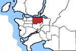
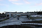
Sullivan Heights is a neighbourhood in Burnaby, just north of Lougheed highway, east of Government road and south of SFU (Simon Fraser University) campus. Bordering the city of Coquitlam and Port Moody, the area is served by the newly operational Millennium Line that connects the city of Coquitlam to other parts of greater Vancouver.
Excerpt from the Wikipedia article Sullivan Heights, Burnaby (License: CC BY-SA 3.0, Authors).Sullivan Heights, Burnaby
Sumas Drive, Burnaby
Geographical coordinates (GPS) Address Nearby Places Show on map
Geographical coordinates (GPS)
| Latitude | Longitude |
|---|---|
| N 49.267 ° | E -122.967 ° |
Address
Sumas Drive
Sumas Drive
V5B 4J8 Burnaby
British Columbia, Canada
Open on Google Maps

